Food nearby Langerfelder Hof
Coronavirus disease (COVID-19) Situation
confirmed cases
38828995
deaths
183027
Germany
Food nearby Langerfelder Hof
Langerfelder Hof
71, Öhder Straße, 42289, Wuppertal, Düsseldorf, DE Germany
contacts phone
:
+49 202 606551
Latitude:
51.260619
, Longitude:
7.2342719
larger map & directions
read more
nearest Food
1.449 km
Hotel Amical
Rauental 24, Wuppertal
Lodging
Restaurant
Food
Point of interest
Establishment
read more
1.449 km
Hotel Amical Barmen - Wuppertal
Rauental 24, Wuppertal
Lodging
Restaurant
Food
Point of interest
Establishment
read more
2.67 km
CaterRent Event-Equipment
Schwarzbach 164, Wuppertal
Food
read more
2.739 km
Party-Pie Deutschland GmbH
Alter Markt 10, Wuppertal
Food
read more
2.862 km
NORMA
Wichlinghauser Markt 19, Wuppertal
Supermarket
Grocery or supermarket
Food
Point of interest
Store
Establishment
read more
3.259 km
af Pack GmbH Wuppertal
Friedrich-Engels-Allee 369, Wuppertal
Food
read more
3.268 km
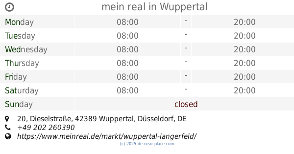
mein real
Dieselstraße 20, Wuppertal
Supermarket
Grocery or supermarket
Store
Food
Point of interest
Establishment
read more
3.523 km
Russischer Partyservice und Catering ZORIN
Buschland 35, Wuppertal
Food
read more
3.625 km
Gaetano Falcone
Rödiger Straße 87, Wuppertal
Food
read more
4.424 km
Bon Appetit
Hünefeldstraße 3-17, Wuppertal
Food
read more
4.593 km
Barnane.net Mietmöbel
Konsumstraße 45, Wuppertal
Food
read more
4.593 km
Schimmelpfennig Partyservice UG (haftungsbeschränkt)
Konsumstraße 45, Wuppertal
Food
read more
4.762 km
Böttger Partyservice
Kölner Straße 11, Schwelm
Food
read more
4.947 km
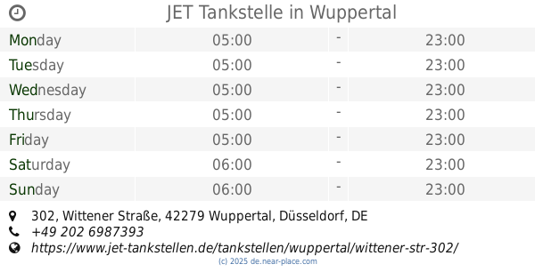
JET Tankstelle
Wittener Straße 302, Wuppertal
Gas station
Car wash
Book store
Supermarket
Grocery or supermarket
Cafe
Restaurant
Food
Point of interest
Store
Establishment
read more
4.994 km
Partyservice Smak
Hofkamp 191, Wuppertal
Food
read more
📑
all categories
Accounting
Administrative area level 1
Administrative area level 2
Airport
Amusement park
Aquarium
Art gallery
Atm
Bakery
Bank
Bar
Beauty salon
Bicycle store
Book store
Bowling alley
Bus station
Cafe
Campground
Car dealer
Car rental
Car repair
Car wash
Casino
Cemetery
Church
City hall
Clothing store
Colloquial area
Convenience store
Country
Courthouse
Dentist
Department store
Doctor
Electrician
Electronics store
Embassy
Establishment
Finance
Fire station
Florist
Food
Funeral home
Furniture store
Gas station
General contractor
Grocery or supermarket
Gym
Hair care
Hardware store
Health
Hindu Temple
Home goods store
Hospital
Insurance agency
Jewelry store
Laundry
Lawyer
Library
Light rail station
Liquor store
Local government office
Locality
Locksmith
Lodging
Meal delivery
Meal takeaway
Mosque
Movie rental
Movie theater
Moving company
Museum
Natural feature
Neighborhood
Night club
Painter
Park
Parking
Pet store
Pharmacy
Physiotherapist
Place of worship
Plumber
Point of interest
Police
Political
Post office
Premise
Real estate agency
Restaurant
Roofing contractor
Route
Rv park, camping
School
Shoe store
Shopping mall
Spa
Stadium
Storage
Store
Subpremise
Subway station
Supermarket
Synagogue
Taxi stand
Train station
Transit station
Travel agency
University
Veterinary care
Zoo
administrative area level 3
administrative area level 4
sublocality level 1
sublocality level 2
sublocality level 3
↑