Food nearby Landhotel Geiselwind
Coronavirus disease (COVID-19) Situation
confirmed cases
38828995
deaths
183027
Germany
Food nearby Landhotel Geiselwind
Landhotel Geiselwind
10, Friedrichstraße, 96160, Geiselwind, Unterfranken, DE Germany
contacts phone
:
+49 9556 92250
website:
www.landhotel-geiselwind.de
Latitude:
49.778528
, Longitude:
10.471236
larger map & directions
read more
nearest Food
9.476 km
Freihof
Freihofgasse 3, Prichsenstadt
Spa
Lodging
Bar
Restaurant
Food
Point of interest
Establishment
read more
9.583 km
SACHS GENUSSATELIER & WEINREISEN
Kniebrecher 8, Castell
Bar
Restaurant
Food
Point of interest
Establishment
read more
10.911 km
Hotel-Gasthof Zum Storch
Marktplatz 20, Schlüsselfeld
Lodging
Restaurant
Food
Point of interest
Establishment
read more
11.098 km
Wörners Schloss Weingut & Wellnesshotel mit Restaurant
Neuses am Sand 21, Prichsenstadt
Restaurant
Lodging
Food
Point of interest
Establishment
read more
12.49 km
Gasthaus Café Waldblick
Bergstraße 37, Rauhenebrach
Cafe
Restaurant
Food
Point of interest
Establishment
read more
13.56 km
EDEKA Kuhn
Hauptstraße 20, Rauhenebrach
Supermarket
Grocery or supermarket
Food
Point of interest
Store
Establishment
read more
16.165 km
Hotel Schloss Reichmannsdorf
Schloßhof 4, Schlüsselfeld
Lodging
Restaurant
Food
Point of interest
Establishment
read more
16.819 km
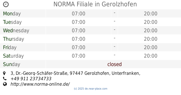
NORMA Filiale
Dr.-Georg-Schäfer-Straße 3, Gerolzhofen
Supermarket
Grocery or supermarket
Food
Point of interest
Store
Establishment
read more
17.48 km
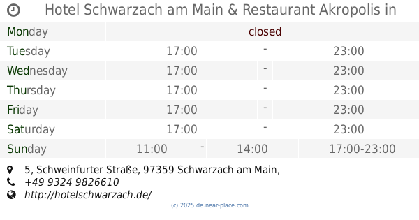
Hotel Schwarzach am Main & Restaurant Akropolis
Schweinfurter Straße 5, Schwarzach am Main
Lodging
Restaurant
Food
Point of interest
Establishment
read more
21.225 km
nah & gut Sauer
Conrad-Vetter-Straße 12, Oberaurach
Supermarket
Grocery or supermarket
Food
Point of interest
Store
Establishment
read more
21.817 km
Netto Marken-Discount
Aischtalweg 1, Uehlfeld
Supermarket
Grocery or supermarket
Food
Point of interest
Store
Establishment
read more
22.192 km
Das Alte Kurhaus, Hotel & Landgasthof
Seeleite 1, Lisberg
Lodging
Restaurant
Food
Point of interest
Establishment
read more
22.696 km
Nahkauf
Am Markt 1, Lisberg
Supermarket
Grocery or supermarket
Liquor store
Food
Point of interest
Store
Establishment
read more
24.342 km
nah & gut Weber
Industriestraße 1, Pommersfelden
Supermarket
Grocery or supermarket
Food
Point of interest
Store
Establishment
read more
24.721 km
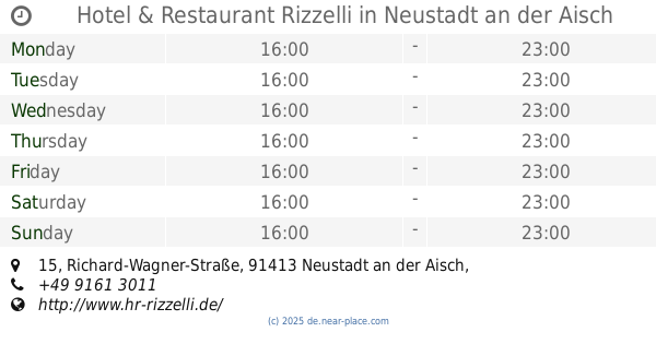
Hotel & Restaurant Rizzelli
Richard-Wagner-Straße 15, Neustadt an der Aisch
Meal delivery
Meal takeaway
Lodging
Restaurant
Food
Point of interest
Establishment
read more
24.889 km
Der Beck
Rothenburger Straße 19, Höchstadt
Bakery
Cafe
Food
Point of interest
Store
Establishment
read more
25.342 km
Der Beck
Marktplatz 3, Höchstadt
Bakery
Cafe
Food
Point of interest
Store
Establishment
read more
25.385 km
Gasthof Zur Post
Hauptstraße 34, Höchstadt
Lodging
Restaurant
Food
Point of interest
Establishment
read more
25.493 km
REWE
Zeiler Straße 58, Sand am Main
Supermarket
Grocery or supermarket
Food
Point of interest
Store
Establishment
read more
25.547 km
Shell
Bamberger Straße 22, Höchstadt
Gas station
Atm
Car wash
Convenience store
Finance
Car repair
Food
Point of interest
Store
Establishment
read more
25.676 km
Triangel Inh. Manfred Kral
Große Bauerngasse 14, Höchstadt
Cafe
Restaurant
Food
Point of interest
Establishment
read more
28.74 km
NORMA Filiale
Industriestraße 7, Bischberg
Supermarket
Grocery or supermarket
Food
Point of interest
Store
Establishment
read more
28.757 km
E center Frischemarkt Meyer
Robert-Bosch-Straße 3, Haßfurt
Supermarket
Grocery or supermarket
Food
Point of interest
Store
Establishment
read more
44.174 km
Der Beck
Paul-Gossen-Straße 69, Erlangen
Bakery
Cafe
Food
Point of interest
Store
Establishment
read more
53.676 km
Duwe Beregnungstechnik
Zirndorfer Straße 90, Nürnberg
Food
read more
📑
all categories
Accounting
Administrative area level 1
Administrative area level 2
Airport
Amusement park
Aquarium
Art gallery
Atm
Bakery
Bank
Bar
Beauty salon
Bicycle store
Book store
Bowling alley
Bus station
Cafe
Campground
Car dealer
Car rental
Car repair
Car wash
Casino
Cemetery
Church
City hall
Clothing store
Colloquial area
Convenience store
Country
Courthouse
Dentist
Department store
Doctor
Electrician
Electronics store
Embassy
Establishment
Finance
Fire station
Florist
Food
Funeral home
Furniture store
Gas station
General contractor
Grocery or supermarket
Gym
Hair care
Hardware store
Health
Hindu Temple
Home goods store
Hospital
Insurance agency
Jewelry store
Laundry
Lawyer
Library
Light rail station
Liquor store
Local government office
Locality
Locksmith
Lodging
Meal delivery
Meal takeaway
Mosque
Movie rental
Movie theater
Moving company
Museum
Natural feature
Neighborhood
Night club
Painter
Park
Parking
Pet store
Pharmacy
Physiotherapist
Place of worship
Plumber
Point of interest
Police
Political
Post office
Premise
Real estate agency
Restaurant
Roofing contractor
Route
Rv park, camping
School
Shoe store
Shopping mall
Spa
Stadium
Storage
Store
Subpremise
Subway station
Supermarket
Synagogue
Taxi stand
Train station
Transit station
Travel agency
University
Veterinary care
Zoo
administrative area level 3
administrative area level 4
sublocality level 1
sublocality level 2
sublocality level 3
↑