Food nearby Kaufland
Coronavirus disease (COVID-19) Situation
confirmed cases
38828995
deaths
183027
Germany
Food nearby Kaufland
Kaufland
19, Robert-Mayer-Straße, 74360, Ilsfeld, Stuttgart, DE Germany
contacts phone
:
+49 7062 9159180
website:
www.filiale.kaufland.de
Latitude:
49.0580456
, Longitude:
9.2610276
larger map & directions
read more
nearest Food
9.84 km
Kaufland Steinheim an der Murr
Steinbeisstraße 15, Steinheim an der Murr
Supermarket
Grocery or supermarket
Food
Point of interest
Store
Establishment
read more
11.149 km
E center Besigheim
Riedstraße 4, Besigheim
Supermarket
Grocery or supermarket
Food
Point of interest
Store
Establishment
read more
13.877 km
Hotel Am Wasen
Wasenstraße 7, Freiberg am Neckar
Lodging
Restaurant
Food
Point of interest
Establishment
read more
14.575 km
JET Tankstelle
Gustav-Rau-Straße 14, Bietigheim-Bissingen
Gas station
Book store
Supermarket
Grocery or supermarket
Cafe
Food
Point of interest
Store
Establishment
read more
15.399 km
Kaufland Bietigheim-Bissingen
Prinz-Eugen-Straße 10, Bietigheim-Bissingen
Supermarket
Grocery or supermarket
Food
Point of interest
Store
Establishment
read more
15.594 km
JET Tankstelle
Bahnhofstraße 149, Bietigheim-Bissingen
Gas station
Book store
Supermarket
Grocery or supermarket
Cafe
Food
Point of interest
Store
Establishment
read more
16.685 km
JET Tankstelle
Hauptstraße 10, Oppenweiler
Gas station
Book store
Supermarket
Grocery or supermarket
Cafe
Restaurant
Food
Point of interest
Store
Establishment
read more
16.726 km
Schlosshotel Monrepos
Domäne, Monrepos 22, Ludwigsburg
Lodging
Restaurant
Food
Point of interest
Establishment
read more
17.94 km
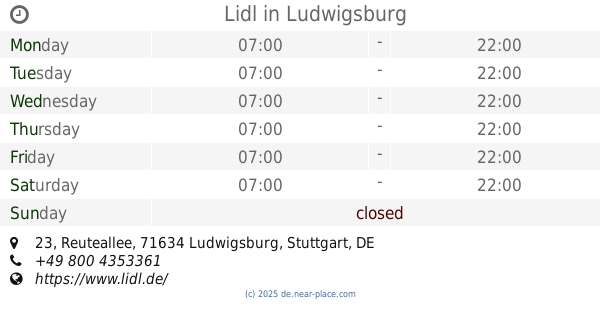
Lidl
Reuteallee 23, Ludwigsburg
Supermarket
Grocery or supermarket
Food
Point of interest
Store
Establishment
read more
19.148 km
nestor Hotel Ludwigsburg
Stuttgarter Straße 35/2, Ludwigsburg
Lodging
Bar
Restaurant
Food
Point of interest
Establishment
read more
19.183 km
Tchibo Filiale
Myliusstraße 15, Ludwigsburg
Cafe
Food
Point of interest
Clothing store
Store
Establishment
read more
19.348 km
Nestlé Deutschland AG Werk Ludwigsburg
Pflugfelder Straße 31, Ludwigsburg
Food
read more
19.376 km
Hotel Adler Asperg
Stuttgarter Straße 2, Asperg
Lodging
Restaurant
Food
Point of interest
Establishment
read more
19.476 km
ALDI Süd
Martin-Luther-Straße 82, Ludwigsburg
Supermarket
Grocery or supermarket
Food
Point of interest
Store
Establishment
read more
19.767 km
Kaufland Ludwigsburg
Schwieberdinger Straße 94, Ludwigsburg
Supermarket
Grocery or supermarket
Food
Point of interest
Store
Establishment
read more
20.123 km
JET Tankstelle
Steinbeisstraße 12, Ludwigsburg
Gas station
Book store
Supermarket
Grocery or supermarket
Cafe
Restaurant
Food
Point of interest
Store
Establishment
read more
21.417 km
Kaffeehaus Krone
Friedensstraße 6, Weissach
Cafe
Restaurant
Food
Point of interest
Establishment
read more
21.532 km
Zum treuen Bartel
Marktplatz 11, Markgröningen
Lodging
Restaurant
Food
Point of interest
Establishment
read more
22.509 km
JET Tankstelle
Waiblinger Straße 15, Winnenden
Gas station
Book store
Supermarket
Grocery or supermarket
Cafe
Restaurant
Food
Point of interest
Store
Establishment
read more
23.617 km
Burghotel Schöne Aussicht
ehemalige Burg Alt-Winnenden, Neuffenstraße 18, Winnenden
Cafe
Lodging
Restaurant
Food
Point of interest
Establishment
read more
23.898 km
Die Marketenderei
Schulstraße 18, Fellbach
Food
read more
24.35 km
Kaufland Stuttgart-Mühlhausen
Aldinger Straße 70, Stuttgart
Supermarket
Grocery or supermarket
Food
Point of interest
Store
Establishment
read more
24.361 km
Chois Coffee GmbH
Benzstraße 35, Fellbach
Food
read more
25.564 km
Stuber Partyservice GmbH
88 Stammheimer Straße, Stuttgart
Food
read more
25.564 km
Stuber Partyservice GmbH
Stammheimer Straße 88, Stuttgart
Food
read more
📑
all categories
Accounting
Administrative area level 1
Administrative area level 2
Airport
Amusement park
Aquarium
Art gallery
Atm
Bakery
Bank
Bar
Beauty salon
Bicycle store
Book store
Bowling alley
Bus station
Cafe
Campground
Car dealer
Car rental
Car repair
Car wash
Casino
Cemetery
Church
City hall
Clothing store
Colloquial area
Convenience store
Country
Courthouse
Dentist
Department store
Doctor
Electrician
Electronics store
Embassy
Establishment
Finance
Fire station
Florist
Food
Funeral home
Furniture store
Gas station
General contractor
Grocery or supermarket
Gym
Hair care
Hardware store
Health
Hindu Temple
Home goods store
Hospital
Insurance agency
Jewelry store
Laundry
Lawyer
Library
Light rail station
Liquor store
Local government office
Locality
Locksmith
Lodging
Meal delivery
Meal takeaway
Mosque
Movie rental
Movie theater
Moving company
Museum
Natural feature
Neighborhood
Night club
Painter
Park
Parking
Pet store
Pharmacy
Physiotherapist
Place of worship
Plumber
Point of interest
Police
Political
Post office
Premise
Real estate agency
Restaurant
Roofing contractor
Route
Rv park, camping
School
Shoe store
Shopping mall
Spa
Stadium
Storage
Store
Subpremise
Subway station
Supermarket
Synagogue
Taxi stand
Train station
Transit station
Travel agency
University
Veterinary care
Zoo
administrative area level 3
administrative area level 4
sublocality level 1
sublocality level 2
sublocality level 3
↑