Food nearby ALDI Hamburg-Winterhude
Germany
Food nearby ALDI Hamburg-Winterhude
ALDI Hamburg-Winterhude
17-25, Barmbeker Straße, 22303, Hamburg, DE Germany
contacts phone
:
+49 800 7234870
website:
www.aldi-nord.de
Latitude:
53.5845888
, Longitude:
10.0184746
larger map & directions
read more
nearest Food
10 m
ALDI Nord
Barmbeker Straße 17-25, Hamburg-Nord
Supermarket
Grocery or supermarket
Store
Food
Point of interest
Establishment
read more
342 m
snacKultur
Hans-Henny-Jahnn-Weg 53, Hamburg
Food
read more
477 m
Dieck & Depré GbR
Gertigstraße 12, Hamburg
Food
read more
570 m
Wildcard Brewing
Barmbeker Straße 74, Hamburg
Food
read more
625 m
Alster City Casino
Weidestraße 122A, Hamburg
Food
read more
704 m
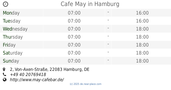
Cafe May
Von-Axen-Straße 2, Hamburg
Cafe
Food
Point of interest
Store
Establishment
read more
704 m
Café May
Von-Axen-Straße 2, Hamburg-Nord
Cafe
Point of interest
Store
Food
Establishment
read more
822 m
Beutehaus GmbH
Poelchaukamp 24, Hamburg
Food
read more
908 m
Bootsvermietung Stadtparksee
Südring 5A, Hamburg
Food
read more
1.569 km
dm
Hamburger Straße 19, Hamburg
Supermarket
Grocery or supermarket
Electronics store
Home goods store
Food
Health
Point of interest
Store
Establishment
read more
1.869 km
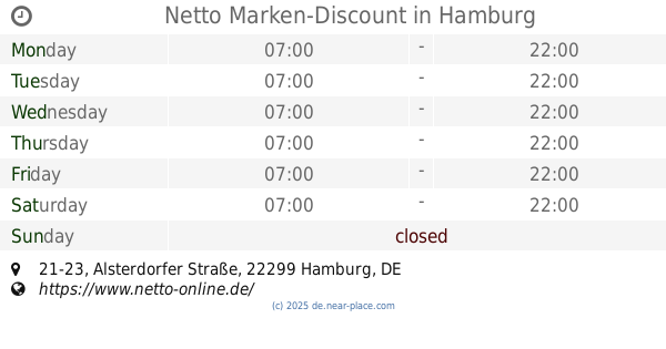
Netto Marken-Discount
Alsterdorfer Straße 21-23, Hamburg
Supermarket
Grocery or supermarket
Food
Point of interest
Store
Establishment
read more
1.871 km
REWE
Holsteinischer Kamp 53, Hamburg
Supermarket
Grocery or supermarket
Food
Point of interest
Store
Establishment
read more
1.951 km
ALDI Nord
Holsteinischer Kamp 65, Hamburg-Nord
Supermarket
Grocery or supermarket
Food
Store
Point of interest
Establishment
read more
2.148 km
Café May
Alsterdorfer Straße 84A, Hamburg
Cafe
Food
Point of interest
Establishment
read more
2.208 km
Café Bodo's Bootssteg
Harvestehuder Weg 1B, Hamburg
Cafe
Food
Point of interest
Store
Establishment
read more
📑
all categories
Accounting
Administrative area level 1
Administrative area level 2
Airport
Amusement park
Aquarium
Art gallery
Atm
Bakery
Bank
Bar
Beauty salon
Bicycle store
Book store
Bowling alley
Bus station
Cafe
Campground
Car dealer
Car rental
Car repair
Car wash
Casino
Cemetery
Church
City hall
Clothing store
Colloquial area
Convenience store
Country
Courthouse
Dentist
Department store
Doctor
Electrician
Electronics store
Embassy
Establishment
Finance
Fire station
Florist
Food
Funeral home
Furniture store
Gas station
General contractor
Grocery or supermarket
Gym
Hair care
Hardware store
Health
Hindu Temple
Home goods store
Hospital
Insurance agency
Jewelry store
Laundry
Lawyer
Library
Light rail station
Liquor store
Local government office
Locality
Locksmith
Lodging
Meal delivery
Meal takeaway
Mosque
Movie rental
Movie theater
Moving company
Museum
Natural feature
Neighborhood
Night club
Painter
Park
Parking
Pet store
Pharmacy
Physiotherapist
Place of worship
Plumber
Point of interest
Police
Political
Post office
Premise
Real estate agency
Restaurant
Roofing contractor
Route
Rv park, camping
School
Shoe store
Shopping mall
Spa
Stadium
Storage
Store
Subpremise
Subway station
Supermarket
Synagogue
Taxi stand
Train station
Transit station
Travel agency
University
Veterinary care
Zoo
administrative area level 3
administrative area level 4
sublocality level 1
sublocality level 2
sublocality level 3
↑