Establishment nearby Konditorei Cafe Frey
Coronavirus disease (COVID-19) Situation
confirmed cases
38828995
deaths
183027
Germany
Establishment nearby Konditorei Cafe Frey
Konditorei Cafe Frey
11, Kirchplatz, 95213, Münchberg, Oberfranken, DE Germany
contacts phone
:
+49 9251 5053
website:
www.konditorei-frey.de
Latitude:
50.1924999
, Longitude:
11.7877727
larger map & directions
read more
nearest Establishment
116 m
Herr Dr. med..dent.Carsten Müller
Torgasse 5, Münchberg
Dentist
Health
Point of interest
Establishment
read more
179 m
Dr. med. dent. Martina Karl
Klosterplatz 3, Münchberg
Dentist
Health
Point of interest
Establishment
read more
247 m
MVZ
Luisenstraße 6, Münchberg
Hospital
Doctor
Health
Point of interest
Establishment
read more
279 m
Zahnarztpraxis Dr. Sabine Kleyla / Dr. Peter Dünninger
Kulmbacher Straße 53, Münchberg
Dentist
Health
Point of interest
Establishment
read more
289 m
Sparkasse Hochfranken - BeratungsCenter
Kirchenlamitzer Straße 6-8, Münchberg
Bank
Finance
Point of interest
Establishment
read more
379 m
Presseshop Heinritz
Stammbacher Straße 3, Münchberg
Post office
Finance
Point of interest
Store
Establishment
read more
415 m
Zahnarztpraxis Dr. Artur Materny
Zelchstraße 18, Münchberg
Dentist
Health
Point of interest
Establishment
read more
425 m
JET Tankstelle
Helmbrechtser Straße 1, Münchberg
Gas station
Book store
Supermarket
Grocery or supermarket
Cafe
Restaurant
Food
Point of interest
Store
Establishment
read more
499 m
Kliniken Hochfranken - Klinik Münchberg Abteilung für Orthopädie Hauptabteilung
Hofer Straße 40, Münchberg
Hospital
Health
Point of interest
Establishment
read more
514 m
Kreiskrankenhaus Münchberg Abteilung für Anästhesie, Intensivmedizin und Notfallmedizin
Hofer Straße 40, Münchberg
Hospital
Health
Point of interest
Establishment
read more
514 m
Kliniken Hochfranken - Klinik Münchberg Abteilung für Innere Medizin
Hofer Straße 40, Münchberg
Hospital
Health
Point of interest
Establishment
read more
516 m
Backhaus Kutzer
Helmbrechtser Straße 4, Münchberg
Bakery
Cafe
Food
Point of interest
Store
Establishment
read more
538 m
Kliniken HochFranken - Münchberg
Hofer Straße 40, Münchberg
Hospital
Health
Point of interest
Establishment
read more
674 m
1897 - Privatrösterei
Wilhelmstraße 27, Münchberg
Cafe
Food
Point of interest
Store
Establishment
read more
713 m
Aral
Stammbacher Straße 45, Münchberg
Gas station
Atm
Car wash
Convenience store
Finance
Food
Point of interest
Store
Establishment
read more
1.118 km
Purucker Bakery | confectionery | Coffee shop
Gewerbegebiet Nord an der A 9, August-Horch-Straße 7, Münchberg
Bakery
Cafe
Food
Point of interest
Store
Establishment
read more
1.17 km
ALDI SÜD
August-Horch-Straße 24, Münchberg
Supermarket
Grocery or supermarket
Food
Point of interest
Store
Establishment
read more
1.643 km
Seehotel Hintere Höhe
Hintere Höhe 7, Münchberg
Lodging
Point of interest
Establishment
read more
1.644 km
Denticulus
Sparnecker Straße 114, Münchberg
Dentist
Health
Point of interest
Establishment
read more
4.684 km
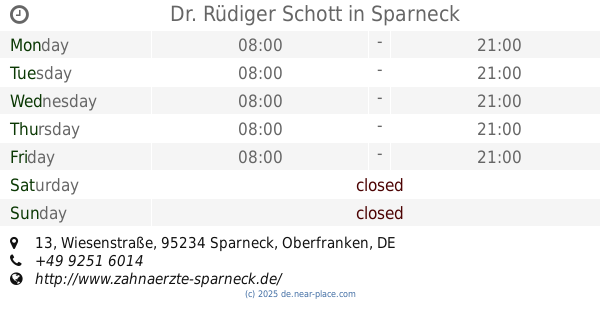
Dr. Rüdiger Schott
Wiesenstraße 13, Sparneck
Dentist
Doctor
Health
Point of interest
Establishment
read more
5.275 km
Raiffeisenbank Sparneck-Zell eG
Marktplatz 7, Sparneck
Bank
Finance
Point of interest
Establishment
read more
7.233 km
Sparkasse Hochfranken - BeratungsCenter
Luitpoldstraße 18-20, Helmbrechts
Bank
Finance
Point of interest
Establishment
read more
9.761 km
Raiffeisenbank Oberland eG , Geschäftsstelle Hohenberg
Pressecker Straße 3, Marktleugast
Bank
Finance
Real estate agency
Point of interest
Establishment
read more
17.289 km
Maxplatz Restaurant
Maxplatz 16, Hof
Cafe
Bar
Restaurant
Food
Point of interest
Establishment
read more
18.438 km
Sparkasse Kulmbach-Kronach - office
Bahnhofstraße 1, Neuenmarkt
Bank
Finance
Point of interest
Establishment
read more
📑
all categories
Accounting
Administrative area level 1
Administrative area level 2
Airport
Amusement park
Aquarium
Art gallery
Atm
Bakery
Bank
Bar
Beauty salon
Bicycle store
Book store
Bowling alley
Bus station
Cafe
Campground
Car dealer
Car rental
Car repair
Car wash
Casino
Cemetery
Church
City hall
Clothing store
Colloquial area
Convenience store
Country
Courthouse
Dentist
Department store
Doctor
Electrician
Electronics store
Embassy
Establishment
Finance
Fire station
Florist
Food
Funeral home
Furniture store
Gas station
General contractor
Grocery or supermarket
Gym
Hair care
Hardware store
Health
Hindu Temple
Home goods store
Hospital
Insurance agency
Jewelry store
Laundry
Lawyer
Library
Light rail station
Liquor store
Local government office
Locality
Locksmith
Lodging
Meal delivery
Meal takeaway
Mosque
Movie rental
Movie theater
Moving company
Museum
Natural feature
Neighborhood
Night club
Painter
Park
Parking
Pet store
Pharmacy
Physiotherapist
Place of worship
Plumber
Point of interest
Police
Political
Post office
Premise
Real estate agency
Restaurant
Roofing contractor
Route
Rv park, camping
School
Shoe store
Shopping mall
Spa
Stadium
Storage
Store
Subpremise
Subway station
Supermarket
Synagogue
Taxi stand
Train station
Transit station
Travel agency
University
Veterinary care
Zoo
administrative area level 3
administrative area level 4
sublocality level 1
sublocality level 2
sublocality level 3
↑