Church nearby St. Mariä Himmelfahrt
Coronavirus disease (COVID-19) Situation
confirmed cases
38828995
deaths
183027
Germany
Church nearby St. Mariä Himmelfahrt
St. Mariä Himmelfahrt
Helenenstraße 7, Essen Germany
contacts phone
:
+49
Latitude:
51.4619577
, Longitude:
6.9807712
read more
nearest Church
248 m
God`s Throne Church e.V. (GTC e.V.)
Dickmannstraße 18, Essen
Church
read more
303 m
God&39s Vision Ministries International e.V.
Oberdorfstraße 20, Essen
Church
read more
579 m
Christuskirche
Röntgenstraße 14, Essen (Ruhr)
Church
read more
656 m
Kindergarten Evangelische Kirche
Grieperstraße 17, Essen
Church
read more
657 m
Ev.Freik. Gemeinde E.-Altendorf - GZA
Haedenkampstraße 30, Essen
Church
read more
980 m
Kirche Am West Bf
Kerckhoffstraße 22B, Essen
Church
read more
1.095 km
St.Clemens Maria Hofbauer
Hirtsieferstraße 13, Essen
Church
read more
1.361 km
Apostolische Gemeinschaft e.V.
Grusonstraße 7, Essen
Church
read more
1.438 km
Gospel Life e.V, Evangelische Freikirche
Westendhof 6, Essen
Church
read more
1.438 km
Gospel Life e. V. // www.gospel-life.de
Westendhof 6, Essen
Church
read more
1.651 km
ICF Essen
Berliner Platz 4, Essen
Church
read more
1.656 km
ICF Essen
Altendorfer Straße 365A, Essen
Church
read more
1.686 km
St. Antonius Essen-Frohnhausen
Kölner Straße 33, Essen
Church
read more
1.73 km
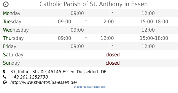
Catholic Parish of St. Anthony
Kölner Straße 37, Essen
Church
read more
1.73 km
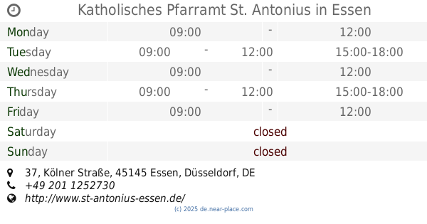
Katholisches Pfarramt St. Antonius
Kölner Straße 37, Essen
Church
read more
1.843 km
Apostelkirche
Mülheimer Straße 72, Essen
Church
read more
1.913 km
Die Heilsarmee Korps Essen
Lazarettstraße 10, Essen
Church
read more
1.917 km
Glorious Chapel Worldwide e. V.
Hindenburgstraße 57, Essen
Church
read more
1.919 km
de l église
Hindenburgstraße 57, Essen
Church
read more
2.052 km
Neuapostolische Kirche
Wiesbadener Straße 59, Essen
Church
read more
2.068 km
Sankt Elisabeth
Frohnhauser Straße 400, Essen (Ruhr)
Church
read more
2.076 km
Kath. Gemeindebüro St. Elisabeth
Frohnhauser Straße 402, Essen
Church
read more
2.15 km
Markuskirche
Postreitweg 80, Essen
Church
read more
2.203 km
Markuszentrum
Postreitweg 80-88, Essen
Church
read more
2.318 km
Neuapostolische Kirche
Germaniastraße 220, Essen
Church
read more
📑
all categories
Accounting
Administrative area level 1
Administrative area level 2
Airport
Amusement park
Aquarium
Art gallery
Atm
Bakery
Bank
Bar
Beauty salon
Bicycle store
Book store
Bowling alley
Bus station
Cafe
Campground
Car dealer
Car rental
Car repair
Car wash
Casino
Cemetery
Church
City hall
Clothing store
Colloquial area
Convenience store
Country
Courthouse
Dentist
Department store
Doctor
Electrician
Electronics store
Embassy
Establishment
Finance
Fire station
Florist
Food
Funeral home
Furniture store
Gas station
General contractor
Grocery or supermarket
Gym
Hair care
Hardware store
Health
Hindu Temple
Home goods store
Hospital
Insurance agency
Jewelry store
Laundry
Lawyer
Library
Light rail station
Liquor store
Local government office
Locality
Locksmith
Lodging
Meal delivery
Meal takeaway
Mosque
Movie rental
Movie theater
Moving company
Museum
Natural feature
Neighborhood
Night club
Painter
Park
Parking
Pet store
Pharmacy
Physiotherapist
Place of worship
Plumber
Point of interest
Police
Political
Post office
Premise
Real estate agency
Restaurant
Roofing contractor
Route
Rv park, camping
School
Shoe store
Shopping mall
Spa
Stadium
Storage
Store
Subpremise
Subway station
Supermarket
Synagogue
Taxi stand
Train station
Transit station
Travel agency
University
Veterinary care
Zoo
administrative area level 3
administrative area level 4
sublocality level 1
sublocality level 2
sublocality level 3
↑