Church nearby Evangel. Free Church congregation Köln-West
Germany
Church nearby Evangel. Free Church congregation Köln-West
Evangel. Free Church congregation Köln-West
Lichtstraße 43, Köln Tyskland
contacts phone
:
+49
Latitude:
50.947931
, Longitude:
6.9086163
read more
nearest Church
267 m
Geistliches Zentrum Vozrozhdenie
Weinsbergstraße 190, Köln
Church
read more
624 m
Церковь Христиан Веры Евангельской
Senefelderstraße 2, Köln
Church
read more
647 m
Friedenskirche
Rothehausstraße 56, Köln
Church
read more
793 m
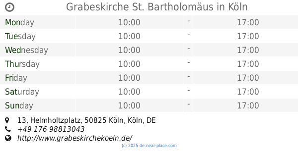
Grabeskirche St. Bartholomäus
Helmholtzplatz 13, Köln
Church
read more
845 m
Pfarrkirche St. Joseph
Venloer Straße 286, Köln
Church
read more
878 m
Marktkapelle St. Mariä Himmelfahrt
Geisselstraße 5, Köln
Church
read more
1.008 km
St. Peter
Simarplatz 23, Köln
Church
read more
1.112 km
Evangelisch-methodistische Markuskirche Köln
Herbigstraße 18, Köln
Church
read more
1.128 km
Evangelische Kirchengemeinde Ehrenfeld
Subbelrather Straße 206, Köln
Church
read more
1.158 km
Pfarrer Siegfried Kuttner Ehrenfeld Verw.Amt s. Bickendorf
Fridolinstraße 31, Köln
Church
read more
1.253 km
Neuapostolische Kirche
Lenaustraße 18, Köln
Church
read more
1.344 km
Sankt Maria Magdalena und Lazarus
Aachener Straße 204, Köln
Church
read more
1.547 km
St. Rochus
Rochusstraße 98, Köln
Church
read more
1.601 km
Kath. Kirchengemeinde Zu den Heiligen Rochus, Dreikönigen und Bartholomäus
Rochusstraße 141, Köln
Church
read more
1.667 km
St. Barbara
Ansgarstraße 5, Köln
Church
read more
1.806 km
Drei Könige
Platanenweg 8, Köln
Church
read more
1.845 km
Kath. Pfarramt St. Dreikönigen
Weißdornweg 91, Köln
Church
read more
1.92 km
Evangelische Kirchengemeinde
Dürener Straße 83, Köln
Church
read more
1.949 km
Pfarrkirche St. Michael
Moltkestraße 117, Köln
Church
read more
2.058 km
Saint Michael
Brüsseler Platz 13-15, Köln
Church
read more
2.182 km
Sekretariat U. Müller
Bachemer Straße 27, Köln
Church
read more
2.236 km
Catholic parish of Christ Resurrection
Jülicher Straße 28, Köln
Church
read more
2.339 km
Buddhistische Meditationsgruppe der Karma Kagyü Gemeinschaft
Jülicher Straße 19, Köln
Church
read more
2.594 km
Ev. Nathanael Kirchengemeinde Köln Bilderstöckchen
Escher Straße 160, Köln
Church
read more
2.598 km
International Baptist Church Cologne
Escher Straße 160, Köln
Church
read more
📑
all categories
Accounting
Administrative area level 1
Administrative area level 2
Airport
Amusement park
Aquarium
Art gallery
Atm
Bakery
Bank
Bar
Beauty salon
Bicycle store
Book store
Bowling alley
Bus station
Cafe
Campground
Car dealer
Car rental
Car repair
Car wash
Casino
Cemetery
Church
City hall
Clothing store
Colloquial area
Convenience store
Country
Courthouse
Dentist
Department store
Doctor
Electrician
Electronics store
Embassy
Establishment
Finance
Fire station
Florist
Food
Funeral home
Furniture store
Gas station
General contractor
Grocery or supermarket
Gym
Hair care
Hardware store
Health
Hindu Temple
Home goods store
Hospital
Insurance agency
Jewelry store
Laundry
Lawyer
Library
Light rail station
Liquor store
Local government office
Locality
Locksmith
Lodging
Meal delivery
Meal takeaway
Mosque
Movie rental
Movie theater
Moving company
Museum
Natural feature
Neighborhood
Night club
Painter
Park
Parking
Pet store
Pharmacy
Physiotherapist
Place of worship
Plumber
Point of interest
Police
Political
Post office
Premise
Real estate agency
Restaurant
Roofing contractor
Route
Rv park, camping
School
Shoe store
Shopping mall
Spa
Stadium
Storage
Store
Subpremise
Subway station
Supermarket
Synagogue
Taxi stand
Train station
Transit station
Travel agency
University
Veterinary care
Zoo
administrative area level 3
administrative area level 4
sublocality level 1
sublocality level 2
sublocality level 3
↑