Cafe nearby Moritzberg
Coronavirus disease (COVID-19) Situation
confirmed cases
38828995
deaths
183027
Germany
Cafe nearby Moritzberg
Moritzberg
Rosental 32, Nürnberg Alemania
contacts phone
:
+49
Latitude:
49.454719
, Longitude:
11.086127
read more
nearest Cafe
649 m
Ice cream shop, ice cream parlor Gelatissimo
Königstraße 2, Nürnberg
Cafe
read more
649 m
Eisdiele, Eiscafe Gelatissimo
Königstraße 2, Nürnberg
Cafe
read more
730 m
Die Maulbeere
Winklerstraße 10, Nürnberg
Cafe
read more
748 m
Casa del Caffe - Espresso Bar
Augustinerstraße 1, Nürnberg
Cafe
read more
785 m
Brewtiful Cafe
Augustinerstraße 3-5, Nürnberg
Cafe
read more
796 m
Nespresso Boutique Nürnberg
Kaiserstraße 23, Nürnberg
Cafe
read more
802 m
Cafe Bar ile
Augustinerstraße 11, Nürnberg
Cafe
read more
851 m
Coffee Fellows
Breite Gasse 5, Nürnberg
Cafe
read more
854 m
Ali Baba Lounge
Meuschelstraße 75, Nürnberg
Cafe
read more
893 m
Santos Bar-Tapas-Cafeteria
Albrecht-Dürer-Straße 24, Nürnberg
Cafe
read more
913 m
Café am Trödelmarkt
Trödelmarkt 42, Nürnberg
Cafe
read more
917 m
Café Bar Wanderer
Beim Tiergärtnertor 6, Nürnberg
Cafe
read more
928 m
Ill Amore
Obere Wörthstraße 10, Nürnberg
Cafe
read more
935 m
Töpferei am Dürerhaus
Neutormauer 25, Nürnberg
Cafe
read more
937 m
Caffé Fiorentino GmbH
Untere Wörthstraße 10-14, Nürnberg
Cafe
read more
945 m
WonderWaffel Nürnberg
Vordere Sterngasse 12, Nürnberg
Cafe
read more
945 m
Starbucks
Breite Gasse 41, Nürnberg
Cafe
read more
981 m
Treppenhaus Lounge
Kornmarkt 6, Nürnberg
Cafe
read more
1.012 km
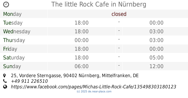
The little Rock Cafe
Vordere Sterngasse 25, Nürnberg
Cafe
read more
1.06 km
Starbucks
Hefnersplatz 10, Nuernberg
Cafe
read more
1.063 km
das Sachers
Hefnersplatz 1, Nürnberg
Cafe
read more
1.063 km
cafe Dalvia
90402, Hefnersplatz, Nürnberg
Cafe
read more
1.072 km
Bistro Arte
Im Germanischen Nationalmuseum, Kartäusergasse 1, Nürnberg
Cafe
read more
1.072 km
Bistro Arte
Germany
Cafe
read more
1.167 km
Langenzenn
Tafelhofstraße, Nürnberg
Cafe
read more
📑
all categories
Accounting
Administrative area level 1
Administrative area level 2
Airport
Amusement park
Aquarium
Art gallery
Atm
Bakery
Bank
Bar
Beauty salon
Bicycle store
Book store
Bowling alley
Bus station
Cafe
Campground
Car dealer
Car rental
Car repair
Car wash
Casino
Cemetery
Church
City hall
Clothing store
Colloquial area
Convenience store
Country
Courthouse
Dentist
Department store
Doctor
Electrician
Electronics store
Embassy
Establishment
Finance
Fire station
Florist
Food
Funeral home
Furniture store
Gas station
General contractor
Grocery or supermarket
Gym
Hair care
Hardware store
Health
Hindu Temple
Home goods store
Hospital
Insurance agency
Jewelry store
Laundry
Lawyer
Library
Light rail station
Liquor store
Local government office
Locality
Locksmith
Lodging
Meal delivery
Meal takeaway
Mosque
Movie rental
Movie theater
Moving company
Museum
Natural feature
Neighborhood
Night club
Painter
Park
Parking
Pet store
Pharmacy
Physiotherapist
Place of worship
Plumber
Point of interest
Police
Political
Post office
Premise
Real estate agency
Restaurant
Roofing contractor
Route
Rv park, camping
School
Shoe store
Shopping mall
Spa
Stadium
Storage
Store
Subpremise
Subway station
Supermarket
Synagogue
Taxi stand
Train station
Transit station
Travel agency
University
Veterinary care
Zoo
administrative area level 3
administrative area level 4
sublocality level 1
sublocality level 2
sublocality level 3
↑