Cafe nearby Free Bird
Coronavirus disease (COVID-19) Situation
confirmed cases
38828995
deaths
183027
Germany
Cafe nearby Free Bird
Free Bird
Eberswalder Straße 29, Berlin Deutschland
contacts phone
:
+49
Latitude:
52.5411816
, Longitude:
13.4107955
read more
nearest Cafe
66 m
California Pops
Eberswalder Straße 32, Berlin
Cafe
read more
95 m
Hair Style
Eberswalder Straße 1, Berlin
Cafe
read more
123 m
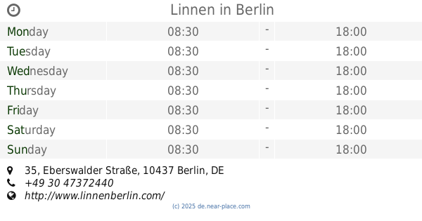
Linnen
Eberswalder Straße 35, Berlin
Cafe
read more
138 m
imogti GmbH & Co. KG
Pappelallee 1, Berlin
Cafe
read more
146 m
Bracas Coffee
Kastanienallee 103, Berlin
Cafe
read more
227 m
OAK & ICE
Schönhauser Allee 52, Berlin
Cafe
read more
303 m
Signorina Yv
Lychener Straße 6, Berlin
Cafe
read more
390 m
Bonanza Coffee Heroes
Oderberger Straße 35, Berlin
Cafe
read more
423 m
Pasticceria Mangiarte
Danziger Straße 23, Berlin
Cafe
read more
512 m
Tilda - coffee eat sleep
Raumerstraße 7, Berlin
Cafe
read more
578 m
Blumencafé
Schönhauser Allee 127A, Berlin
Cafe
read more
629 m
Kiezkind Berlin
Auf dem Helmholtzplatz 1, Berlin
Cafe
read more
654 m
Vegan Tiger
Lettestraße 5, Berlin
Cafe
read more
709 m
Samer Café
Gleimstraße 44, Berlin
Cafe
read more
784 m
Krümel Espressobar
73 Stargarder Straße, Berlin
Cafe
read more
801 m
Café It's Love
36, Pappelallee, Berlin
Cafe
read more
857 m
Betty'n'Caty 2
Knaackstraße 28, Berlin
Cafe
read more
860 m
Café Seeblick
Rykestraße 14, Berlin
Cafe
read more
868 m
ANNACHRON Café und Möbelsalon
Kopenhagener Straße 64, Berlin
Cafe
read more
897 m
Aapka - Indisches Restaurant Berlin
Kastanienallee 50, Berlin
Meal takeaway
Cafe
Bar
Restaurant
Food
Point of interest
Establishment
read more
1000 m
Oma Marnies Pie Bakery
Hiddenseer Straße 13, Berlin
Cafe
read more
1.041 km
Cafe` Hortus
Prenzlauer Allee 224, Berlin
Cafe
read more
1.215 km
Café Blaumond
Immanuelkirchstraße 3, Berlin
Cafe
read more
1.235 km
ducks and cats
Winsstraße 58, Berlin
Cafe
read more
1.26 km
KAFFE
Immanuelkirchstraße 6, Berlin
Cafe
read more
📑
all categories
Accounting
Administrative area level 1
Administrative area level 2
Airport
Amusement park
Aquarium
Art gallery
Atm
Bakery
Bank
Bar
Beauty salon
Bicycle store
Book store
Bowling alley
Bus station
Cafe
Campground
Car dealer
Car rental
Car repair
Car wash
Casino
Cemetery
Church
City hall
Clothing store
Colloquial area
Convenience store
Country
Courthouse
Dentist
Department store
Doctor
Electrician
Electronics store
Embassy
Establishment
Finance
Fire station
Florist
Food
Funeral home
Furniture store
Gas station
General contractor
Grocery or supermarket
Gym
Hair care
Hardware store
Health
Hindu Temple
Home goods store
Hospital
Insurance agency
Jewelry store
Laundry
Lawyer
Library
Light rail station
Liquor store
Local government office
Locality
Locksmith
Lodging
Meal delivery
Meal takeaway
Mosque
Movie rental
Movie theater
Moving company
Museum
Natural feature
Neighborhood
Night club
Painter
Park
Parking
Pet store
Pharmacy
Physiotherapist
Place of worship
Plumber
Point of interest
Police
Political
Post office
Premise
Real estate agency
Restaurant
Roofing contractor
Route
Rv park, camping
School
Shoe store
Shopping mall
Spa
Stadium
Storage
Store
Subpremise
Subway station
Supermarket
Synagogue
Taxi stand
Train station
Transit station
Travel agency
University
Veterinary care
Zoo
administrative area level 3
administrative area level 4
sublocality level 1
sublocality level 2
sublocality level 3
↑