Cafe nearby Café Muku
Coronavirus disease (COVID-19) Situation
confirmed cases
38828995
deaths
183027
Germany
Cafe nearby Café Muku
Café Muku
Burgwiese 9, Bielefeld Tyskland
contacts phone
:
+49
Latitude:
52.014833
, Longitude:
8.524614
read more
nearest Cafe
397 m
Johnson's
Artur-Ladebeck-Straße 5, Bielefeld
Cafe
read more
527 m
Villa Bozi
Albrecht-Delius-Weg 2, Bielefeld
Cafe
read more
530 m
GourmetService
Albrecht-Delius-Weg 2, Bielefeld
Cafe
read more
550 m
Café Gemach
Neustädter Straße 10, Bielefeld
Cafe
read more
583 m
Eiscafe la Fenice
Obernstraße 27, Bielefeld
Cafe
read more
584 m
Café Melodita
Waldhof 15, Bielefeld
Cafe
read more
645 m
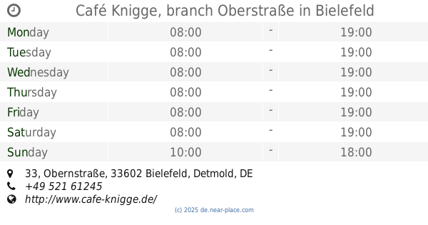
Café Knigge, branch Oberstraße
Obernstraße 33, Bielefeld
Cafe
read more
663 m
Gutzeitcafe
Niederwall 61, Bielefeld
Cafe
read more
747 m
Schlösschen Bielefeld
Niederwall 44, Bielefeld
Cafe
read more
767 m
Der Teeraum
Ritterstraße 4, Bielefeld
Cafe
read more
777 m
Katzencafé Miezhaus
Oberntorwall 10, Bielefeld
Cafe
read more
784 m
Kachelhaus Bielefeld
Hagenbruchstraße 13, Bielefeld
Cafe
read more
786 m
M Kaffee
Gehrenberg 7-9, Bielefeld
Cafe
read more
793 m
The Coffee Store
Obernstraße 2, Bielefeld
Cafe
read more
794 m
Thumel 1504
Gehrenberg 3, Bielefeld
Cafe
read more
823 m
Giovanni L.
Rathausstraße 1, Bielefeld
Cafe
read more
825 m
Il Barista Coffee
Alter Markt 10, Bielefeld
Cafe
read more
845 m
Café Knigge "Schokoli"
Güsenstraße 2, Bielefeld
Cafe
read more
846 m
Cafe Posithiv
Stapenhorststraße 5, Bielefeld
Cafe
read more
867 m
JOSI´S
Alfred-Bozi-Straße 14, Bielefeld
Cafe
read more
887 m
Café Knigge, Filiale Niedernstraße
Niedernstraße 15, Bielefeld
Cafe
read more
935 m
Cafe Wölke Inh. Dirk Windau e K.
Detmolder Straße 49-51, Bielefeld
Cafe
read more
954 m
Café Kraume
Stapenhorststraße 10, Bielefeld
Cafe
read more
959 m
Café Alfama
Niederwall 12, Bielefeld
Cafe
read more
1.066 km
CafeNio
Niederwall 23, Bielefeld
Cafe
read more
📑
all categories
Accounting
Administrative area level 1
Administrative area level 2
Airport
Amusement park
Aquarium
Art gallery
Atm
Bakery
Bank
Bar
Beauty salon
Bicycle store
Book store
Bowling alley
Bus station
Cafe
Campground
Car dealer
Car rental
Car repair
Car wash
Casino
Cemetery
Church
City hall
Clothing store
Colloquial area
Convenience store
Country
Courthouse
Dentist
Department store
Doctor
Electrician
Electronics store
Embassy
Establishment
Finance
Fire station
Florist
Food
Funeral home
Furniture store
Gas station
General contractor
Grocery or supermarket
Gym
Hair care
Hardware store
Health
Hindu Temple
Home goods store
Hospital
Insurance agency
Jewelry store
Laundry
Lawyer
Library
Light rail station
Liquor store
Local government office
Locality
Locksmith
Lodging
Meal delivery
Meal takeaway
Mosque
Movie rental
Movie theater
Moving company
Museum
Natural feature
Neighborhood
Night club
Painter
Park
Parking
Pet store
Pharmacy
Physiotherapist
Place of worship
Plumber
Point of interest
Police
Political
Post office
Premise
Real estate agency
Restaurant
Roofing contractor
Route
Rv park, camping
School
Shoe store
Shopping mall
Spa
Stadium
Storage
Store
Subpremise
Subway station
Supermarket
Synagogue
Taxi stand
Train station
Transit station
Travel agency
University
Veterinary care
Zoo
administrative area level 3
administrative area level 4
sublocality level 1
sublocality level 2
sublocality level 3
↑