Cafe nearby Cafe Marientreff
Coronavirus disease (COVID-19) Situation
confirmed cases
38828995
deaths
183027
Germany
Cafe nearby Cafe Marientreff
Cafe Marientreff
Bei der Marienkirche 1, Rostock Germany
contacts phone
:
+49
Latitude:
54.0891133
, Longitude:
12.1372334
read more
nearest Cafe
106 m
Eiswerkstatt Rostock
Kröpeliner Straße 18, Rostock
Cafe
read more
130 m
Spielcafe 1 + 2
Kistenmacherstraße 15, Rostock
Cafe
read more
157 m
Rostocker Tea House - Teeladen
Kröpeliner Straße 26, Rostock
Cafe
read more
172 m
Jan & Mitch Café Bar
Breite Straße 12, Rostock
Cafe
read more
175 m
Vapiano
Neuer Markt 9, Rostock
Cafe
read more
183 m
Das Kaffeehaus UG (haftungsbeschränkt) & Co. KG Rostock
Lange Straße 10, Rostock
Cafe
read more
186 m
Grand Cafe
Universitätsplatz 8, Rostock
Cafe
read more
190 m
Das Kaffeehaus
Lange Straße 10, Rostock
Cafe
read more
250 m
Coffeebox
Lange Straße 29-31, Rostock
Cafe
read more
347 m
Café Kloster
Klosterhof 6, Rostock
Cafe
read more
463 m
GIOVANNI L.
Kröpeliner Straße 54, Rostock
Cafe
read more
470 m
Likörfabrik
Grubenstraße 1, Rostock
Cafe
read more
474 m
Starbucks
Kröpeliner Straße 54, Rostock
Cafe
read more
484 m
Leon's Coffee Shop
Nördliche Altstadt, Rostock
Cafe
read more
487 m
Miss Milla Rostock
Kröpeliner Straße 54, Rostock
Cafe
read more
527 m
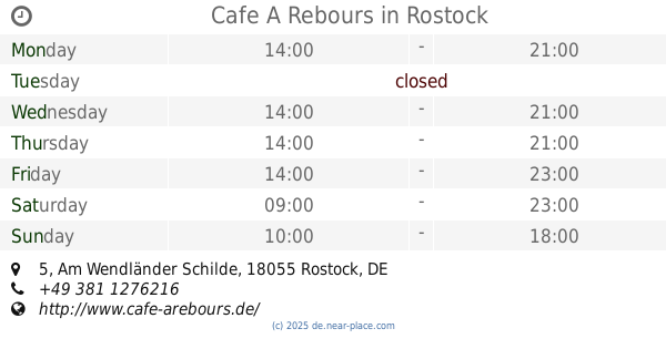
Cafe A Rebours
Am Wendländer Schilde 5, Rostock
Cafe
read more
676 m
Café Paula
Paulstraße 21, Rostock
Cafe
read more
709 m
Cado's Café & Crêperie
Oberhalb d. Gerberbruches 8, Rostock
Cafe
read more
770 m
Café Ockel
Friedrich-Engels-Platz 4, Rostock
Cafe
read more
801 m
OSPA Cafeteria
Am Vögenteich 23, Rostock
Cafe
read more
843 m
Café La Vie
Friedhofsweg 44A, Rostock
Cafe
read more
895 m
Ronjaespresso
Doberaner Straße 158, Rostock
Cafe
read more
973 m
Cafe am Hopfenmarkt
Friedrichstraße 2, Rostock
Cafe
read more
980 m
Cafeteria Regina Löhn
Rosa-Luxemburg-Straße 32, Rostock
Cafe
read more
981 m
Thum Juling
klopstock str, Klopstockstraße 5, Rostock
Cafe
read more
📑
all categories
Accounting
Administrative area level 1
Administrative area level 2
Airport
Amusement park
Aquarium
Art gallery
Atm
Bakery
Bank
Bar
Beauty salon
Bicycle store
Book store
Bowling alley
Bus station
Cafe
Campground
Car dealer
Car rental
Car repair
Car wash
Casino
Cemetery
Church
City hall
Clothing store
Colloquial area
Convenience store
Country
Courthouse
Dentist
Department store
Doctor
Electrician
Electronics store
Embassy
Establishment
Finance
Fire station
Florist
Food
Funeral home
Furniture store
Gas station
General contractor
Grocery or supermarket
Gym
Hair care
Hardware store
Health
Hindu Temple
Home goods store
Hospital
Insurance agency
Jewelry store
Laundry
Lawyer
Library
Light rail station
Liquor store
Local government office
Locality
Locksmith
Lodging
Meal delivery
Meal takeaway
Mosque
Movie rental
Movie theater
Moving company
Museum
Natural feature
Neighborhood
Night club
Painter
Park
Parking
Pet store
Pharmacy
Physiotherapist
Place of worship
Plumber
Point of interest
Police
Political
Post office
Premise
Real estate agency
Restaurant
Roofing contractor
Route
Rv park, camping
School
Shoe store
Shopping mall
Spa
Stadium
Storage
Store
Subpremise
Subway station
Supermarket
Synagogue
Taxi stand
Train station
Transit station
Travel agency
University
Veterinary care
Zoo
administrative area level 3
administrative area level 4
sublocality level 1
sublocality level 2
sublocality level 3
↑