Bar nearby Skala
Coronavirus disease (COVID-19) Situation
confirmed cases
38828995
deaths
183027
Germany
Bar nearby Skala
Skala
Gottschedstraße 16, Leipzig Germany
contacts phone
:
+49
Latitude:
51.3413801
, Longitude:
12.3671277
read more
nearest Bar
14 m
Little Vision
Käthe-Kollwitz-Straße 10, Leipzig
Bar
read more
45 m
Jamboree
Käthe-Kollwitz-Straße 11, Leipzig
Bar
read more
74 m
CHECK IN BAR
Käthe-Kollwitz-Straße 15, Leipzig
Bar
read more
249 m
Varadero
Gottschedstraße 4, Leipzig
Bar
read more
385 m
Goldhopfen - Craft Beer Bar Leipzig
Kolonnadenstraße 11, Leipzig
Bar
read more
404 m
Enchilada Leipzig
Richard-Wagner-Platz 1, Leipzig
Bar
read more
421 m
Restaurant Cafe Madrid
Klostergasse 3-5, Leipzig
Bar
read more
423 m
Bobbys Sportsbar Leipzig
Jahnallee 21, Leipzig
Bar
read more
454 m
Institut für Zukunft
Zentrum, Leipzig
Bar
read more
456 m
Barfusz
Markt 9, Leipzig
Bar
read more
528 m
Brauhaus an der Thomaskirche
Thomaskirchhof 3-5, Leipzig
Bar
read more
541 m
Vinothek 1770 - mehr als Wein
Tröndlinring 8, Leipzig
Bar
read more
604 m
"Fra Diavolo" | Ristorante + Pizzeria
Burgplatz 2, Leipzig
Bar
read more
636 m
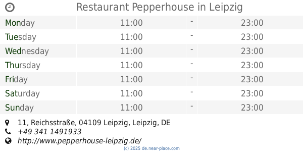
Restaurant Pepperhouse
Reichsstraße 11, Leipzig
Bar
read more
688 m
Dhillons Irish Bar & Grill
Reichsstraße 18, Leipzig
Bar
read more
716 m
Adina Apartment Hotel Leipzig
Brühl 50, Leipzig
Bar
read more
760 m
Beefers Premium Grill
Martin-Luther-Ring 2, Leipzig
Bar
read more
775 m
Indian Palace
Nikolaistraße 12-14, Leipzig
Bar
read more
791 m
Leipzig Fankneipe
Waldstraße 29, Leipzig
Bar
read more
795 m
Restaurant El Matador
Friedrich-Ebert-Straße 108, Leipzig
Bar
read more
802 m
The First Whisk (e) y Bar Leipzig
Nikolaistraße 6-10, Strohsackpassage/ Ausgang Ritterstraße, Leipzig
Bar
read more
876 m
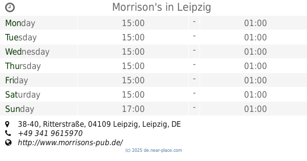
Morrison's
Ritterstraße 38-40, Leipzig
Bar
read more
1.003 km
Bierbar Gleis 8
Willy-Brandt-Platz 5, Leipzig
Bar
read more
1.161 km
BAR e.V.
Grünewaldstraße 19, Leipzig
Bar
read more
1.397 km
Leipzig Studentenkeller e.V.
Nürnberger Straße 42, Leipzig
Bar
read more
📑
all categories
Accounting
Administrative area level 1
Administrative area level 2
Airport
Amusement park
Aquarium
Art gallery
Atm
Bakery
Bank
Bar
Beauty salon
Bicycle store
Book store
Bowling alley
Bus station
Cafe
Campground
Car dealer
Car rental
Car repair
Car wash
Casino
Cemetery
Church
City hall
Clothing store
Colloquial area
Convenience store
Country
Courthouse
Dentist
Department store
Doctor
Electrician
Electronics store
Embassy
Establishment
Finance
Fire station
Florist
Food
Funeral home
Furniture store
Gas station
General contractor
Grocery or supermarket
Gym
Hair care
Hardware store
Health
Hindu Temple
Home goods store
Hospital
Insurance agency
Jewelry store
Laundry
Lawyer
Library
Light rail station
Liquor store
Local government office
Locality
Locksmith
Lodging
Meal delivery
Meal takeaway
Mosque
Movie rental
Movie theater
Moving company
Museum
Natural feature
Neighborhood
Night club
Painter
Park
Parking
Pet store
Pharmacy
Physiotherapist
Place of worship
Plumber
Point of interest
Police
Political
Post office
Premise
Real estate agency
Restaurant
Roofing contractor
Route
Rv park, camping
School
Shoe store
Shopping mall
Spa
Stadium
Storage
Store
Subpremise
Subway station
Supermarket
Synagogue
Taxi stand
Train station
Transit station
Travel agency
University
Veterinary care
Zoo
administrative area level 3
administrative area level 4
sublocality level 1
sublocality level 2
sublocality level 3
↑