Bar nearby PH74
Coronavirus disease (COVID-19) Situation
confirmed cases
38828995
deaths
183027
Germany
Bar nearby PH74
PH74
Kalscheurener Straße 19A, Hürth Niemcy
contacts phone
:
+49
Latitude:
50.8925869
, Longitude:
6.9054948
read more
nearest Bar
PH74 - Chill 'n Grill
Kalscheurener Straße 19 a, Hürth
Bar
read more
272 m
Op d'r Eck Hürth-Efferen
Kaulardstraße 10, Hürth
Bar
read more
572 m
Hotel Schütze
Ritterstraße 25, Hürth
Bar
read more
1.726 km
Skyline
Weidengasse 1, Hürth
Bar
read more
1.884 km
Zolliwood 121
50969, Köln
Bar
read more
1.927 km
Kiosk & Bootsverleih Kalscheurer Weiher
Zollstock, Köln
Bar
read more
1.952 km
Kleingärtnerverein Neuenhof e.V.
Zollstocker Weg 103, Köln
Bar
read more
1.952 km
Wolli`s BRETTERBUD
Zollstocker Weg 103, Köln-Hönigen
Bar
read more
2.016 km
Em Stübchen
Severinusstraße 4, Hürth
Bar
read more
2.221 km
Soul's Pub
Gielsdorfweg 4, Hürth
Bar
read more
2.59 km
Butcher's Sportsbar
Berrenrather Straße 377, Köln
Bar
read more
2.645 km
Long Island Restaurant Cocktailbar Cafe'
Theresienhöhe 3, Hürth
Bar
read more
2.771 km
Petersberger Hof
Petersbergstraße 41, Köln
Bar
read more
2.914 km
Sölzer Klaaf
Gerolsteiner Straße 16, Köln
Bar
read more
2.927 km
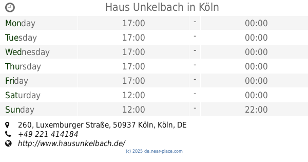
Haus Unkelbach
Luxemburger Straße 260, Köln
Bar
read more
2.97 km
CocktailContor
Sülzgürtel 76A, Köln
Bar
read more
2.979 km
Klettenberger Hof
Siebengebirgsallee 89, Köln
Bar
read more
3.091 km
Schlösselche
Sülzburgstraße 94, Köln
Bar
read more
3.184 km
Stauss
Berrenrather Straße 244, Köln
Bar
read more
3.222 km
Kleiner Kurfürst
Luxemburger Straße 218, Köln
Bar
read more
3.233 km
4cl - Cocktail Service GBR
Einhardstraße 1, Köln
Bar
read more
3.431 km
Caffé MACCHIATO Espressobars GmbH
Gottesweg 2-26, Köln
Bar
read more
3.578 km
Refugium
Herthastraße 1, Köln
Bar
read more
3.672 km
Gaststätte Sandys
Weierstraße 17, Hürth
Bar
read more
3.74 km
Lord of the Grillz - Mittelalterliches Grill- & Steakhaus
Vorgebirgstraße 102, Köln
Bar
read more
📑
all categories
Accounting
Administrative area level 1
Administrative area level 2
Airport
Amusement park
Aquarium
Art gallery
Atm
Bakery
Bank
Bar
Beauty salon
Bicycle store
Book store
Bowling alley
Bus station
Cafe
Campground
Car dealer
Car rental
Car repair
Car wash
Casino
Cemetery
Church
City hall
Clothing store
Colloquial area
Convenience store
Country
Courthouse
Dentist
Department store
Doctor
Electrician
Electronics store
Embassy
Establishment
Finance
Fire station
Florist
Food
Funeral home
Furniture store
Gas station
General contractor
Grocery or supermarket
Gym
Hair care
Hardware store
Health
Hindu Temple
Home goods store
Hospital
Insurance agency
Jewelry store
Laundry
Lawyer
Library
Light rail station
Liquor store
Local government office
Locality
Locksmith
Lodging
Meal delivery
Meal takeaway
Mosque
Movie rental
Movie theater
Moving company
Museum
Natural feature
Neighborhood
Night club
Painter
Park
Parking
Pet store
Pharmacy
Physiotherapist
Place of worship
Plumber
Point of interest
Police
Political
Post office
Premise
Real estate agency
Restaurant
Roofing contractor
Route
Rv park, camping
School
Shoe store
Shopping mall
Spa
Stadium
Storage
Store
Subpremise
Subway station
Supermarket
Synagogue
Taxi stand
Train station
Transit station
Travel agency
University
Veterinary care
Zoo
administrative area level 3
administrative area level 4
sublocality level 1
sublocality level 2
sublocality level 3
↑