Bar nearby Mittelblond Kulturkneipe
Coronavirus disease (COVID-19) Situation
confirmed cases
38828995
deaths
183027
Germany
Bar nearby Mittelblond Kulturkneipe
Mittelblond Kulturkneipe
Schwalbengasse 2, Köln Deutschland
contacts phone
:
+49
Latitude:
50.9401955
, Longitude:
6.9500697
read more
nearest Bar
452 m
Friesen Bar
Friesenstraße 41, Köln
Bar
read more
462 m
Hemingway
Friesenstraße 43, Köln
Bar
read more
474 m
Santa Clara GmbH
Friesenstraße 47, Köln
Bar
read more
489 m
DOMCUP Gastroverwaltungs GmbH
Apostelnstraße 2, Köln
Bar
read more
500 m
Maracana Rodizio
Friesenstraße 55, Köln
Bar
read more
553 m
Köwa
Im Klapperhof 29, Köln
Bar
read more
554 m
Goldfinger
Friesenstraße 54, Köln
Bar
read more
608 m
11cl Cocktailkurse @ Abhörbar
Friesenwall 128, Köln
Bar
read more
613 m
Love Story Discothek & Bar GmbH
Friesenwall 116, Köln
Bar
read more
743 m
J. & M. Buschmann Klimperkasten oHG
Alter Markt 50-52, Köln
Bar
read more
767 m
Mariechen
51, Am Rinkenpfuhl, Köln
Bar
read more
768 m
Täglich
Alter Markt 26, Köln
Bar
read more
768 m
Cafe Täglich
Alter Markt 26, Köln
Bar
read more
772 m
Die Kulisse Köln Altstadt
Unter Käster 14-16, Köln
Bar
read more
801 m
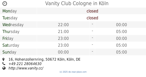
Vanity Club Cologne
Hohenzollernring 16, Köln
Bar
read more
842 m
Kecks
Salzgasse 3-5, Köln
Bar
read more
843 m
Sadie's Irish Pub
Gereonswall 45, Köln
Bar
read more
846 m
ycb your coffee brands GmbH
Hansaring 61, Köln
Bar
read more
853 m
Baustelle 4U
5, Pipinstraße, Köln
Bar
read more
866 m
Taberna Flamenca
Salzgasse 8, Köln
Bar
read more
884 m
Zentralgarderobe Bermudadreieck
Schaafenstraße 49, Köln
Bar
read more
929 m
GEDANKENtanken Gastro GmbH
Genter Straße 8, Köln
Bar
read more
948 m
Weinevents und Weinseminare Köln
Domstraße 45, Köln
Bar
read more
976 m
The Harp
Venloer Straße 22, Köln
Bar
read more
1.077 km
Papa Rudis
Waidmarkt 2, Köln
Bar
read more
📑
all categories
Accounting
Administrative area level 1
Administrative area level 2
Airport
Amusement park
Aquarium
Art gallery
Atm
Bakery
Bank
Bar
Beauty salon
Bicycle store
Book store
Bowling alley
Bus station
Cafe
Campground
Car dealer
Car rental
Car repair
Car wash
Casino
Cemetery
Church
City hall
Clothing store
Colloquial area
Convenience store
Country
Courthouse
Dentist
Department store
Doctor
Electrician
Electronics store
Embassy
Establishment
Finance
Fire station
Florist
Food
Funeral home
Furniture store
Gas station
General contractor
Grocery or supermarket
Gym
Hair care
Hardware store
Health
Hindu Temple
Home goods store
Hospital
Insurance agency
Jewelry store
Laundry
Lawyer
Library
Light rail station
Liquor store
Local government office
Locality
Locksmith
Lodging
Meal delivery
Meal takeaway
Mosque
Movie rental
Movie theater
Moving company
Museum
Natural feature
Neighborhood
Night club
Painter
Park
Parking
Pet store
Pharmacy
Physiotherapist
Place of worship
Plumber
Point of interest
Police
Political
Post office
Premise
Real estate agency
Restaurant
Roofing contractor
Route
Rv park, camping
School
Shoe store
Shopping mall
Spa
Stadium
Storage
Store
Subpremise
Subway station
Supermarket
Synagogue
Taxi stand
Train station
Transit station
Travel agency
University
Veterinary care
Zoo
administrative area level 3
administrative area level 4
sublocality level 1
sublocality level 2
sublocality level 3
↑