Bar nearby Linie 5
Coronavirus disease (COVID-19) Situation
confirmed cases
38828995
deaths
183027
Germany
Bar nearby Linie 5
Linie 5
Oskar-Hoffmann-Straße 97, Bochum Deutschland
contacts phone
:
+49
Latitude:
51.474237
, Longitude:
7.2260867
read more
nearest Bar
526 m
Kneipe Grammophon
Wittener Straße 83, Bochum
Bar
read more
629 m
New Orleans
Südring 11, Bochum
Bar
read more
695 m
Bermuda3eck Infopoint
Kortumstraße 2, Bochum
Bar
read more
695 m
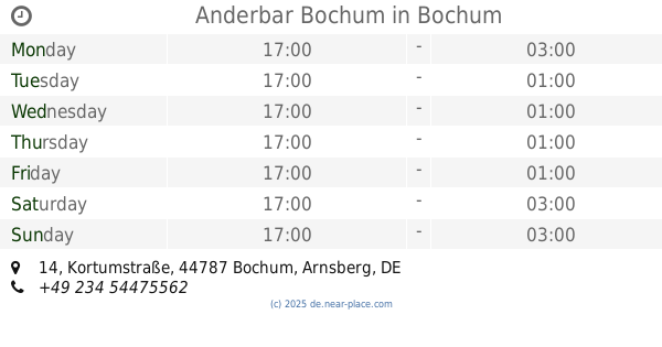
Anderbar Bochum
Kortumstraße 14, Bochum
Bar
read more
698 m
Bermuda3Eck
Kortumstraße 2, Bochum
Bar
read more
700 m
Mississippi
Kortumstraße 16, Bochum
Bar
read more
704 m
Mocca Cocktailbar
Kortumstraße 20, Bochum
Bar
read more
706 m
Brinkhoffs No.1
Brüderstraße 13, Bochum
Bar
read more
707 m
Das Zentral - Caffé Bar Restaurant
Luisenstraße 15-17, Bochum
Bar
read more
708 m
Who Goes
Kortumstraße 22, Bochum
Bar
read more
723 m
Badalona Bar
Brüderstraße 2, Bochum
Bar
read more
727 m
Bermuda Sisha - Lounge - Cafe - Bar
Brüderstraße 10, Bochum
Bar
read more
727 m
Cotton Club
Kortumstraße 1, Bochum
Bar
read more
728 m
Pinte
Kortumstraße 11, Bochum
Bar
read more
731 m
SAUSALITOS Bochum
Kortumstraße 13, Bochum
Bar
read more
732 m
Lennox
Kortumstraße 7, Bochum
Bar
read more
740 m
Flashbacks
Konrad-Adenauer-Platz 1, Bochum
Bar
read more
742 m
Biercafe
Hubertusstraße 4, Bochum
Bar
read more
784 m
Café Bar Jedermanns
Kerkwege 2-4, Bochum
Bar
read more
792 m
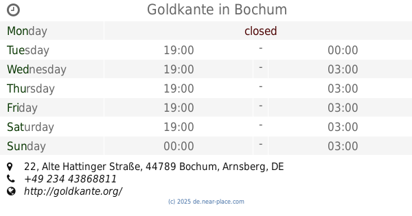
Goldkante
Alte Hattinger Straße 22, Bochum
Bar
read more
800 m
Intershop
Viktoriastraße 53A, Bochum
Bar
read more
834 m
Mufasa Bar
Südring 24, Bochum
Bar
read more
946 m
Zur Postkutsche
Viktoriastraße 16, Bochum
Bar
read more
1.097 km
Neuland
Rottstraße 15, Bochum
Bar
read more
1.114 km
Zum Kuhhirten
Brückstraße 12, Bochum
Bar
read more
📑
all categories
Accounting
Administrative area level 1
Administrative area level 2
Airport
Amusement park
Aquarium
Art gallery
Atm
Bakery
Bank
Bar
Beauty salon
Bicycle store
Book store
Bowling alley
Bus station
Cafe
Campground
Car dealer
Car rental
Car repair
Car wash
Casino
Cemetery
Church
City hall
Clothing store
Colloquial area
Convenience store
Country
Courthouse
Dentist
Department store
Doctor
Electrician
Electronics store
Embassy
Establishment
Finance
Fire station
Florist
Food
Funeral home
Furniture store
Gas station
General contractor
Grocery or supermarket
Gym
Hair care
Hardware store
Health
Hindu Temple
Home goods store
Hospital
Insurance agency
Jewelry store
Laundry
Lawyer
Library
Light rail station
Liquor store
Local government office
Locality
Locksmith
Lodging
Meal delivery
Meal takeaway
Mosque
Movie rental
Movie theater
Moving company
Museum
Natural feature
Neighborhood
Night club
Painter
Park
Parking
Pet store
Pharmacy
Physiotherapist
Place of worship
Plumber
Point of interest
Police
Political
Post office
Premise
Real estate agency
Restaurant
Roofing contractor
Route
Rv park, camping
School
Shoe store
Shopping mall
Spa
Stadium
Storage
Store
Subpremise
Subway station
Supermarket
Synagogue
Taxi stand
Train station
Transit station
Travel agency
University
Veterinary care
Zoo
administrative area level 3
administrative area level 4
sublocality level 1
sublocality level 2
sublocality level 3
↑