Bar nearby König Pilsener Bierhaus
Coronavirus disease (COVID-19) Situation
confirmed cases
38828995
deaths
183027
Germany
Bar nearby König Pilsener Bierhaus
König Pilsener Bierhaus
Gladbecker Straße 25, Bottrop Alemania
contacts phone
:
+49
Latitude:
51.524285
, Longitude:
6.9279769
read more
nearest Bar
9 m
Gastromeile - Gladbecker Str.
Gladbecker Straße 25, Bottrop
Bar
read more
52 m
Q-Bar
Gladbecker Straße 20, Bottrop
Bar
read more
59 m
Hürter
Gladbecker Straße 19A, Bottrop
Bar
read more
76 m
Bodega
Gladbecker Straße 31, Bottrop
Bar
read more
76 m
Bodega Tapas Bar
Gladbecker Straße 31, Bottrop
Bar
read more
102 m
Internetcafe
Horster Straße 26, Bottrop
Bar
read more
135 m
Bogart
Gladbecker Straße 41, Bottrop
Bar
read more
191 m
Zum Krug
Friedrich-Ebert-Straße 134, Bottrop
Bar
read more
200 m
Rathausschänke
Kirchhellener Straße 21, Bottrop
Bar
read more
391 m
شيشا بار DDS بوتروب
Bottrop
Bar
read more
450 m
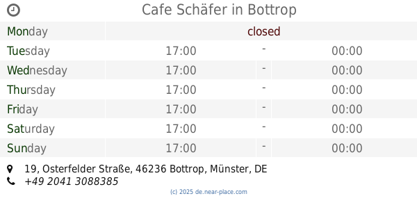
Cafe Schäfer
Osterfelder Straße 19, Bottrop
Bar
read more
450 m
Caffee Schäfer
Osterfelder Straße 19, Bottrop
Bar
read more
554 m
Unikat Shisha Bar Bottrop
Osterfelderstraße 20, Bottrop
Bar
read more
657 m
Albers Wettboerse GmbH
Neustraße 2, Bottrop
Bar
read more
657 m
Albers Wettbörse GmbH
Neustraße 2, Bottrop
Bar
read more
822 m
Pappala Pub
Essener Straße 42, Bottrop
Bar
read more
905 m
Städt. Jugendcafé Prosper III
Kardinal-Hengsbach-Straße 1, Bottrop
Bar
read more
1.644 km
Tanzlokal Nina
Am Südring-Center 7, Bottrop
Bar
read more
2.644 km
Markstuben
Im Fuhlenbrock 141, Bottrop
Bar
read more
3.867 km
Schottes Kneipe
Teutoburger Straße 156, Oberhausen
Bar
read more
4.938 km
Parking
Sulterkamp 62, Essen
Bar
read more
5.073 km
CentrO Beach
CentrO-Promenade 50, Oberhausen
Bar
read more
5.487 km
Dallas Lounge
Hafenstraße 100, Essen
Bar
read more
5.882 km
Elkes Treff
Alter Postweg 126, Bottrop
Bar
read more
6.202 km
Centreville
Im Lipperfeld 23, Oberhausen
Bar
read more
📑
all categories
Accounting
Administrative area level 1
Administrative area level 2
Airport
Amusement park
Aquarium
Art gallery
Atm
Bakery
Bank
Bar
Beauty salon
Bicycle store
Book store
Bowling alley
Bus station
Cafe
Campground
Car dealer
Car rental
Car repair
Car wash
Casino
Cemetery
Church
City hall
Clothing store
Colloquial area
Convenience store
Country
Courthouse
Dentist
Department store
Doctor
Electrician
Electronics store
Embassy
Establishment
Finance
Fire station
Florist
Food
Funeral home
Furniture store
Gas station
General contractor
Grocery or supermarket
Gym
Hair care
Hardware store
Health
Hindu Temple
Home goods store
Hospital
Insurance agency
Jewelry store
Laundry
Lawyer
Library
Light rail station
Liquor store
Local government office
Locality
Locksmith
Lodging
Meal delivery
Meal takeaway
Mosque
Movie rental
Movie theater
Moving company
Museum
Natural feature
Neighborhood
Night club
Painter
Park
Parking
Pet store
Pharmacy
Physiotherapist
Place of worship
Plumber
Point of interest
Police
Political
Post office
Premise
Real estate agency
Restaurant
Roofing contractor
Route
Rv park, camping
School
Shoe store
Shopping mall
Spa
Stadium
Storage
Store
Subpremise
Subway station
Supermarket
Synagogue
Taxi stand
Train station
Transit station
Travel agency
University
Veterinary care
Zoo
administrative area level 3
administrative area level 4
sublocality level 1
sublocality level 2
sublocality level 3
↑