Bar nearby Karamel
Coronavirus disease (COVID-19) Situation
confirmed cases
38828995
deaths
183027
Germany
Bar nearby Karamel
Karamel
Zanggasse 17, Mainz Alemania
contacts phone
:
+49
Latitude:
50.0021223
, Longitude:
8.2629442
read more
nearest Bar
39 m
Hobby
Zanggasse 28, Mainz
Bar
read more
109 m
Good Time
Hintere Bleiche 8, Mainz
Bar
read more
173 m
Kelly's Pub
Schottstraße 2, Mainz
Bar
read more
181 m
Bavaria
Bahnhofstraße 12, Mainz
Bar
read more
187 m
Schick und Schön
Kaiserstraße 15, Mainz
Bar
read more
205 m
Havin Türküevi
Parcusstraße 3, Mainz
Bar
read more
243 m
Bonifaziusstube
Bonifaziusplatz 1, Mainz
Bar
read more
278 m
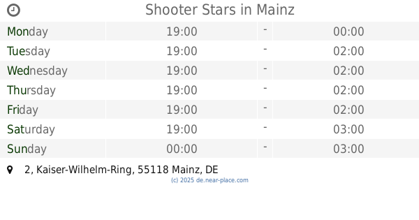
Shooter Stars
Kaiser-Wilhelm-Ring 2, Mainz
Bar
read more
307 m
Irishpub-Steakhouse Unternehmergesellschaft (haftungsbeschränkt)
Bahnhofplatz 1, Mainz
Bar
read more
364 m
Chez Luc
Frauenlobstraße 21, Mainz
Bar
read more
605 m
Die Bierbumb
59, Frauenlobstraße, Mainz
Bar
read more
630 m
SAUSALITOS
Mitternachtsgasse 1, Mainz
Bar
read more
757 m
The Great Gatsby
Drususstraße 1, Mainz
Bar
read more
776 m
Kaiser-Wilhelm-Eck
Kaiser-Wilhelm-Ring 49, Mainz
Bar
read more
789 m
Linas Bar
Alemanha, Kaiser-Wilhelm-Ring 51, Mainz
Bar
read more
817 m
Die Kugel
Hindenburgstraße 51, Mainz
Bar
read more
829 m
Rita's Treff
Leibnitzstraße 55, Mainz
Bar
read more
831 m
Kneipche
Gaustraße 17, Mainz
Bar
read more
872 m
Mainzstrand
Adenauer-Ufer, Mainz
Bar
read more
932 m
Smisha Bar
Kirschgarten 20, Mainz
Bar
read more
942 m
Craft Beer Bar Mainz
Heringsbrunnengasse 1, Mainz
Bar
read more
970 m
Weinstube Rote Kopf
Rotekopfgasse 4, Mainz a Rhein
Bar
read more
989 m
Kneipe Domsgickel
Grebenstraße 16, Mainz
Bar
read more
1.131 km
Sofra II
Hopfengarten 21, Mainz
Bar
read more
1.218 km
Weinstube Lösch
Jakobsbergstraße 9, Mainz
Bar
read more
📑
all categories
Accounting
Administrative area level 1
Administrative area level 2
Airport
Amusement park
Aquarium
Art gallery
Atm
Bakery
Bank
Bar
Beauty salon
Bicycle store
Book store
Bowling alley
Bus station
Cafe
Campground
Car dealer
Car rental
Car repair
Car wash
Casino
Cemetery
Church
City hall
Clothing store
Colloquial area
Convenience store
Country
Courthouse
Dentist
Department store
Doctor
Electrician
Electronics store
Embassy
Establishment
Finance
Fire station
Florist
Food
Funeral home
Furniture store
Gas station
General contractor
Grocery or supermarket
Gym
Hair care
Hardware store
Health
Hindu Temple
Home goods store
Hospital
Insurance agency
Jewelry store
Laundry
Lawyer
Library
Light rail station
Liquor store
Local government office
Locality
Locksmith
Lodging
Meal delivery
Meal takeaway
Mosque
Movie rental
Movie theater
Moving company
Museum
Natural feature
Neighborhood
Night club
Painter
Park
Parking
Pet store
Pharmacy
Physiotherapist
Place of worship
Plumber
Point of interest
Police
Political
Post office
Premise
Real estate agency
Restaurant
Roofing contractor
Route
Rv park, camping
School
Shoe store
Shopping mall
Spa
Stadium
Storage
Store
Subpremise
Subway station
Supermarket
Synagogue
Taxi stand
Train station
Transit station
Travel agency
University
Veterinary care
Zoo
administrative area level 3
administrative area level 4
sublocality level 1
sublocality level 2
sublocality level 3
↑