Bar nearby Jäger Biergarten
Coronavirus disease (COVID-19) Situation
confirmed cases
38828995
deaths
183027
Germany
Bar nearby Jäger Biergarten
Jäger Biergarten
Kutschenweg 8, Rheinstetten Germany
contacts phone
:
+49
Latitude:
48.96339
, Longitude:
8.33443
read more
nearest Bar
1.053 km
Seegugger
Rheinstetten
Bar
read more
1.995 km
Schwarzwaldstube
Hauptstraße 45, Rheinstetten
Bar
read more
2.063 km
Linie 2
Karlsruher Straße 23, Rheinstetten
Bar
read more
2.283 km
Pilsstube
Hauptstraße 14, Rheinstetten
Bar
read more
2.642 km
Jutta Seyfert Imbiß
Sommerstraße 31, Rheinstetten
Bar
read more
2.898 km
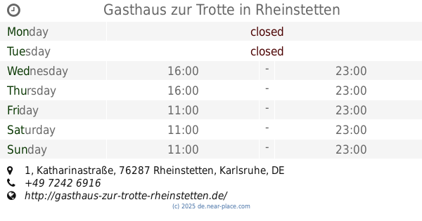
Gasthaus zur Trotte
Katharinastraße 1, Rheinstetten
Bar
read more
3.132 km
Do Dul
Schillerstraße, Karlsruhe
Bar
read more
3.256 km
Zum wilden Hirsch
Hirschstraße 17, Rheinstetten
Bar
read more
3.337 km
Radisson Blu Hotel, Karlsruhe
Am Hardtwald 10, Ettlingen
Bar
read more
4.745 km
Bierhäusle
Lange Straße 72, Karlsruhe
Bar
read more
4.802 km
Schwarzer Adler – Daxlandener urige Kneipe
Inselstraße 28, Karlsruhe
Bar
read more
4.949 km
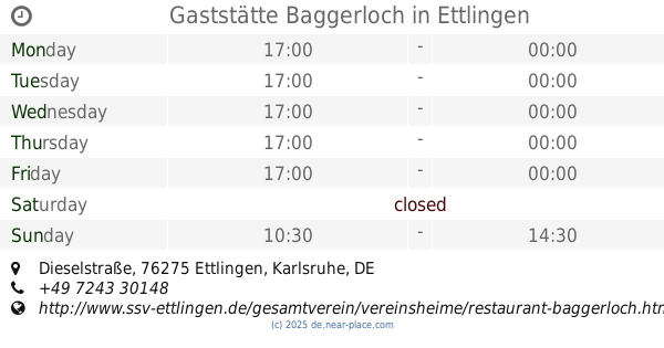
Gaststätte Baggerloch
Dieselstraße, Ettlingen
Bar
read more
5.287 km
Ristorante Adria
Breite Straße 24, Karlsruhe
Bar
read more
5.313 km
Goldener Becher
Kriegsstraße 185, Karlsruhe
Bar
read more
5.357 km
Tivoli - Gaststätte mit Biergarten
Speyerer Straße 91, Durmersheim
Bar
read more
5.373 km
Café Saloon
Marie-Alexandra-Straße 3, Karlsruhe
Bar
read more
5.53 km
Atlantic Bar
Brauerstraße 40, Karlsruhe
Bar
read more
5.729 km
Church-Chill Sportsbar
Karlstraße 115, Karlsruhe
Bar
read more
5.914 km
KORFU
Bahnhofstraße 1, Durmersheim
Bar
read more
5.935 km
Luis Espressobar
Bahnhofplatz 1, Karlsruhe
Bar
read more
5.994 km
MAPA Food & Drinks
Gartenstraße 56B, Karlsruhe
Bar
read more
6.055 km
Santo´s Cocktailbar
Karlstraße 69, Karlsruhe
Bar
read more
6.366 km
BW Chillz
Ettlingen
Bar
read more
6.387 km
Die Pinte
Leopoldstraße 15, Karlsruhe
Bar
read more
6.666 km
Cafe Stern
Bürgerstraße 9C, Karlsruhe
Bar
read more
📑
all categories
Accounting
Administrative area level 1
Administrative area level 2
Airport
Amusement park
Aquarium
Art gallery
Atm
Bakery
Bank
Bar
Beauty salon
Bicycle store
Book store
Bowling alley
Bus station
Cafe
Campground
Car dealer
Car rental
Car repair
Car wash
Casino
Cemetery
Church
City hall
Clothing store
Colloquial area
Convenience store
Country
Courthouse
Dentist
Department store
Doctor
Electrician
Electronics store
Embassy
Establishment
Finance
Fire station
Florist
Food
Funeral home
Furniture store
Gas station
General contractor
Grocery or supermarket
Gym
Hair care
Hardware store
Health
Hindu Temple
Home goods store
Hospital
Insurance agency
Jewelry store
Laundry
Lawyer
Library
Light rail station
Liquor store
Local government office
Locality
Locksmith
Lodging
Meal delivery
Meal takeaway
Mosque
Movie rental
Movie theater
Moving company
Museum
Natural feature
Neighborhood
Night club
Painter
Park
Parking
Pet store
Pharmacy
Physiotherapist
Place of worship
Plumber
Point of interest
Police
Political
Post office
Premise
Real estate agency
Restaurant
Roofing contractor
Route
Rv park, camping
School
Shoe store
Shopping mall
Spa
Stadium
Storage
Store
Subpremise
Subway station
Supermarket
Synagogue
Taxi stand
Train station
Transit station
Travel agency
University
Veterinary care
Zoo
administrative area level 3
administrative area level 4
sublocality level 1
sublocality level 2
sublocality level 3
↑