Bar nearby Imbiss Zum Ruhrtal
Coronavirus disease (COVID-19) Situation
confirmed cases
38828995
deaths
183027
Germany
Bar nearby Imbiss Zum Ruhrtal
Imbiss Zum Ruhrtal
Hagener Straße 178, Schwerte Niemcy
contacts phone
:
+49
Latitude:
51.42821
, Longitude:
7.55662
read more
nearest Bar
1.563 km
Ausflugsgaststätte Amsel am RuhrtalRadweg in Schwerte
Im Reiche des Wassers 11, Schwerte
Bar
read more
1.891 km
Vereinsheim VfB Westhofen
Wasserstraße 17, Schwerte
Bar
read more
2.263 km
Haus Zier
Reichshofstraße 107, Schwerte
Bar
read more
2.409 km
Haus Tiemesmann
Hörder Straße 28, Schwerte
Bar
read more
2.973 km
Gaststätte Heidekrug
Heideweg 44, Dortmund
Bar
read more
4.744 km
Natur-Biergarten Zur Lennemündung
Syburger Dorfstraße 69, Dortmund
Bar
read more
4.777 km
Gastronomie Spielbank Hohensyburg
Hohensyburgstraße 200, Dortmund
Bar
read more
7.266 km
Krönchen
Köln-Berliner Straße 35, Dortmund
Bar
read more
7.531 km
Löwenkäfig
Im Kley 1, Hagen
Bar
read more
7.653 km
Spaghetti Lounge
Hagener Straße 545, Dortmund
Bar
read more
8.897 km
Litfass
Friedensstraße, Hagen
Bar
read more
8.901 km
Gaststätte Winterberg
Rembergstraße 65, Hagen
Bar
read more
9.463 km
Alt Nürnberg
Elbersufer 10, Hagen , Westf
Bar
read more
9.476 km
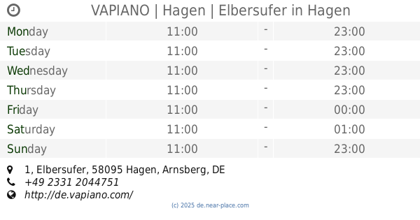
VAPIANO | Hagen | Elbersufer
Elbersufer 1, Hagen
Bar
read more
9.738 km
Käfig
Märkischer Ring 124, Hagen
Bar
read more
9.828 km
Wirtshaus am Ring
Bergischer Ring 6, Hagen
Bar
read more
10.42 km
SKY-BAR
Breierspfad, Dortmund
Bar
read more
10.835 km
Grill Store Arneckestraße
Arneckestraße 88, Dortmund
Bar
read more
10.852 km
Steakhouse Rodizio
Rosemeyerstraße 2-4, Dortmund
Bar
read more
11.328 km
Atlantico Café
Weißenburger Straße 35, Dortmund
Bar
read more
11.661 km
MATO lounge
Burgwall 8, Dortmund
Bar
read more
11.909 km
777 Bar Cardi Lounge
Stahlwerkstraße 31A, Dortmund
Bar
read more
12.351 km
zur Palette
Alsenstraße 79, Dortmund
Bar
read more
12.464 km
Haspe City
Hasperbruch, Hagen
Bar
read more
18.089 km
BARBARIS - Lounge Shisha Bar
Westerfilder Straße 36, Dortmund
Bar
read more
📑
all categories
Accounting
Administrative area level 1
Administrative area level 2
Airport
Amusement park
Aquarium
Art gallery
Atm
Bakery
Bank
Bar
Beauty salon
Bicycle store
Book store
Bowling alley
Bus station
Cafe
Campground
Car dealer
Car rental
Car repair
Car wash
Casino
Cemetery
Church
City hall
Clothing store
Colloquial area
Convenience store
Country
Courthouse
Dentist
Department store
Doctor
Electrician
Electronics store
Embassy
Establishment
Finance
Fire station
Florist
Food
Funeral home
Furniture store
Gas station
General contractor
Grocery or supermarket
Gym
Hair care
Hardware store
Health
Hindu Temple
Home goods store
Hospital
Insurance agency
Jewelry store
Laundry
Lawyer
Library
Light rail station
Liquor store
Local government office
Locality
Locksmith
Lodging
Meal delivery
Meal takeaway
Mosque
Movie rental
Movie theater
Moving company
Museum
Natural feature
Neighborhood
Night club
Painter
Park
Parking
Pet store
Pharmacy
Physiotherapist
Place of worship
Plumber
Point of interest
Police
Political
Post office
Premise
Real estate agency
Restaurant
Roofing contractor
Route
Rv park, camping
School
Shoe store
Shopping mall
Spa
Stadium
Storage
Store
Subpremise
Subway station
Supermarket
Synagogue
Taxi stand
Train station
Transit station
Travel agency
University
Veterinary care
Zoo
administrative area level 3
administrative area level 4
sublocality level 1
sublocality level 2
sublocality level 3
↑