Bar nearby Hubertusklause
Coronavirus disease (COVID-19) Situation
confirmed cases
38828995
deaths
183027
Germany
Bar nearby Hubertusklause
Hubertusklause
Leostraße 37, Troisdorf Alemania
contacts phone
:
+49
Latitude:
50.8041278
, Longitude:
7.1263072
read more
nearest Bar
2.307 km
SCAPE PALACE in Troisdorf - Cafe - Shishalounge - Cocktailbar
Kölner Straße 135, Troisdorf
Bar
read more
5.104 km
Wirtshaus "Zur Post"
Provinzialstraße 23, Niederkassel
Bar
read more
5.146 km
Op de Eck
Provinzialstraße 15, Niederkassel
Bar
read more
5.198 km
Restaurant Schlimgen
Provinzialstraße 8, Niederkassel
Bar
read more
5.442 km
Billard-Center Hangelar GmbH
Kölnstraße 4, Sankt Augustin
Bar
read more
5.555 km
Mondi-Beachbar
Rheinallee 27, Niederkassel
Bar
read more
5.569 km
Mondorf Beachclub
Niederkassel
Bar
read more
5.654 km
Sion im Carre
Neue Poststraße 15, Siegburg
Bar
read more
6.223 km
Bistro Café Laternchen
Alte Heerstraße 63, Sankt Augustin
Bar
read more
7.021 km
KulturKneipe Brotfabrik
Kreuzstraße 16, Bonn
Bar
read more
7.076 km
Pizza Bonn
Siegburger Straße 11, Bonn
Bar
read more
7.411 km
Bonnum
Paulstraße 7, Bonn
Bar
read more
7.633 km
Steinbeck
Breite Straße 35, Bonn
Bar
read more
7.731 km
Jacob's Playground
Oxfordstraße 21, Bonn
Bar
read more
9.75 km
Jannis - Gyros
Bonner Straße 29, Bornheim
Bar
read more
10.902 km
Pavillon Rheinauenpark,WC möglichkeit
Ludwig-Erhard-Allee 20, Bonn
Bar
read more
11.08 km
Consulado Argentino En Bonn
Robert-Koch-Straße 104, Bonn
Bar
read more
15.261 km
Ostheimer Hof
Werntgenstraße 33, Köln
Bar
read more
17.301 km
Sportbar Italia
Ohmstraße 8, Köln
Bar
read more
18.491 km
OASIS
Kennedy-Ufer 1, Köln
Bar
read more
18.801 km
Taberna Flamenca
Salzgasse 8, Köln
Bar
read more
18.906 km
Cafe Täglich
Alter Markt 26, Köln
Bar
read more
18.965 km
J. & M. Buschmann Klimperkasten oHG
Alter Markt 50-52, Köln
Bar
read more
19.323 km
Shepheard
Rathenauplatz 5, Köln
Bar
read more
19.787 km
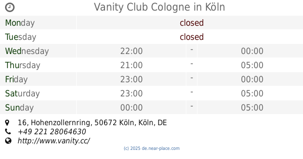
Vanity Club Cologne
Hohenzollernring 16, Köln
Bar
read more
📑
all categories
Accounting
Administrative area level 1
Administrative area level 2
Airport
Amusement park
Aquarium
Art gallery
Atm
Bakery
Bank
Bar
Beauty salon
Bicycle store
Book store
Bowling alley
Bus station
Cafe
Campground
Car dealer
Car rental
Car repair
Car wash
Casino
Cemetery
Church
City hall
Clothing store
Colloquial area
Convenience store
Country
Courthouse
Dentist
Department store
Doctor
Electrician
Electronics store
Embassy
Establishment
Finance
Fire station
Florist
Food
Funeral home
Furniture store
Gas station
General contractor
Grocery or supermarket
Gym
Hair care
Hardware store
Health
Hindu Temple
Home goods store
Hospital
Insurance agency
Jewelry store
Laundry
Lawyer
Library
Light rail station
Liquor store
Local government office
Locality
Locksmith
Lodging
Meal delivery
Meal takeaway
Mosque
Movie rental
Movie theater
Moving company
Museum
Natural feature
Neighborhood
Night club
Painter
Park
Parking
Pet store
Pharmacy
Physiotherapist
Place of worship
Plumber
Point of interest
Police
Political
Post office
Premise
Real estate agency
Restaurant
Roofing contractor
Route
Rv park, camping
School
Shoe store
Shopping mall
Spa
Stadium
Storage
Store
Subpremise
Subway station
Supermarket
Synagogue
Taxi stand
Train station
Transit station
Travel agency
University
Veterinary care
Zoo
administrative area level 3
administrative area level 4
sublocality level 1
sublocality level 2
sublocality level 3
↑