Bar nearby Gaststätte "SIMPA"
Coronavirus disease (COVID-19) Situation
confirmed cases
38828995
deaths
183027
Germany
Bar nearby Gaststätte "SIMPA"
Gaststätte "SIMPA"
Kroatenweg 12, Magdeburg Alemania
contacts phone
:
+49
Latitude:
52.1083519
, Longitude:
11.5923224
read more
nearest Bar
4 m
DROPS Pub und Spielsalon
Kroatenweg 12, Magdeburg
Bar
read more
51 m
Deja'-vu
Magdeburg
Bar
read more
174 m
Sportsbar Zuckerfabrik
Halberstädter Straße 183, Magdeburg
Bar
read more
474 m
0acht15, Volker Stolte
Halberstädter Straße 138, Magdeburg
Bar
read more
474 m
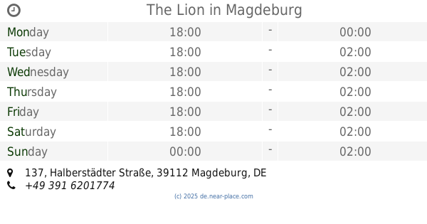
The Lion
Halberstädter Straße 137, Magdeburg
Bar
read more
826 m
Izze's Bierstube
Braunschweiger Straße, Magdeburg
Bar
read more
839 m
Reha-Sport-Verein KRAFTWERK e.V.
Salzmannstraße 23, Magdeburg
Bar
read more
919 m
Gaststätte Kreuzbube
Braunschweiger Straße 107, Magdeburg
Bar
read more
1.108 km
New York Bar
Magdeburg
Bar
read more
1.13 km
Biergarten
Bodestraße, Magdeburg
Bar
read more
1.351 km
Bistro Linie 1
Am Sudenburger Bahnhof 3, Magdeburg
Bar
read more
1.374 km
Gasthaus Erdenglück
Fermersleber Weg 45i, Magdeburg
Bar
read more
1.409 km
Katis Eck
Frankefelde 71, Magdeburg
Bar
read more
1.609 km
Fritz-Rödel-Heim "Scheune"
Lilienweg 52a, Magdeburg
Bar
read more
1.643 km
Billardhouse
Liebknechtstraße 89, Magdeburg
Bar
read more
1.647 km
BOYS´n`BEATS
Liebknechtstraße 89, Magdeburg
Bar
read more
1.882 km
Sansi Bar
Leipziger Straße, Magdeburg
Bar
read more
1.918 km
Bar
Leipziger Straße, Magdeburg
Bar
read more
2.343 km
Nachtcafe La notte
Große Diesdorfer Straße 65, Magdeburg
Bar
read more
2.809 km
Kartell
Breiter Weg 232A, Magdeburg
Bar
read more
2.876 km
Einstein. Die Bierkneipe
Einsteinstraße 3, Magdeburg
Bar
read more
2.93 km
Monalisa Barbe such
Keplerstraße 4A, Magdeburg
Night club
Bar
Point of interest
Establishment
read more
2.979 km
Xampanyeria
Breiter Weg 226, Magdeburg
Bar
read more
3.255 km
Fast wie zu Hause
Ahornweg 19A, Magdeburg
Bar
read more
3.806 km
Vapiano Magdeburg
Ulrichplatz 1, Magdeburg
Bar
read more
📑
all categories
Accounting
Administrative area level 1
Administrative area level 2
Airport
Amusement park
Aquarium
Art gallery
Atm
Bakery
Bank
Bar
Beauty salon
Bicycle store
Book store
Bowling alley
Bus station
Cafe
Campground
Car dealer
Car rental
Car repair
Car wash
Casino
Cemetery
Church
City hall
Clothing store
Colloquial area
Convenience store
Country
Courthouse
Dentist
Department store
Doctor
Electrician
Electronics store
Embassy
Establishment
Finance
Fire station
Florist
Food
Funeral home
Furniture store
Gas station
General contractor
Grocery or supermarket
Gym
Hair care
Hardware store
Health
Hindu Temple
Home goods store
Hospital
Insurance agency
Jewelry store
Laundry
Lawyer
Library
Light rail station
Liquor store
Local government office
Locality
Locksmith
Lodging
Meal delivery
Meal takeaway
Mosque
Movie rental
Movie theater
Moving company
Museum
Natural feature
Neighborhood
Night club
Painter
Park
Parking
Pet store
Pharmacy
Physiotherapist
Place of worship
Plumber
Point of interest
Police
Political
Post office
Premise
Real estate agency
Restaurant
Roofing contractor
Route
Rv park, camping
School
Shoe store
Shopping mall
Spa
Stadium
Storage
Store
Subpremise
Subway station
Supermarket
Synagogue
Taxi stand
Train station
Transit station
Travel agency
University
Veterinary care
Zoo
administrative area level 3
administrative area level 4
sublocality level 1
sublocality level 2
sublocality level 3
↑