Bar nearby Gaststätte Dunas
Coronavirus disease (COVID-19) Situation
confirmed cases
38828995
deaths
183027
Germany
Bar nearby Gaststätte Dunas
Gaststätte Dunas
19, Bahnhofstraße, 24223, Schwentinental, DE Niemcy
contacts phone
:
+49 4307 211
Latitude:
54.2809724
, Longitude:
10.2432322
larger map & directions
read more
nearest Bar
3.661 km
Schwentine Stübchen
1, Kirchensteig, Schwentinental
Bar
read more
3.756 km
Klausdorfer Hof - Hotel-Restaurant-Saal
Schwentinestraße 2, Schwentinental
Bar
read more
3.994 km
Zum Wellsee - S. Arlt
Am Wellsee 6, Kiel
Bar
read more
4.351 km
Bredeneeker Gasthaus
An der Spolsau 1, Rastorf
Bar
read more
4.361 km
Rumpelstilzchen
Andreas-Hofer-Platz 9, Kiel
Bar
read more
4.436 km
Angie´s Treff
Landecker Weg 53, Kiel
Bar
read more
4.436 km
Angie´s Treff
Landecker Weg 53, Kiel , Ostsee
Bar
read more
5.936 km
SVE Comet Kiel
Passader Straße 16, Kiel
Bar
read more
6.11 km
Sportheim Rethwisch
Dorfstraße, Lehmkuhlen
Bar
read more
6.68 km
Sportgaststätte 'Baukampfbahn'
Röntgenstraße 5, Kiel
Bar
read more
6.97 km
Holsten-Krug
Medusastraße 13, Kiel
Bar
read more
7.995 km
KASKADE
Wall 48, Kiel
Bar
read more
8.012 km
Käpt'n Flint
Wall 58, Kiel
Bar
read more
8.091 km
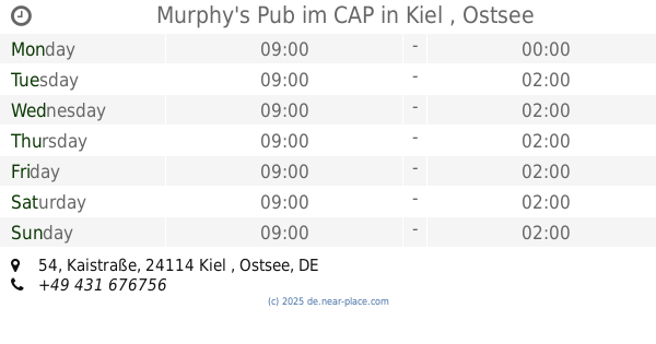
Murphy's Pub im CAP
Kaistraße 54, Kiel , Ostsee
Bar
read more
8.135 km
Deck 8 - die Bar im ATLANTIC Hotel Kiel
Raiffeisenstraße 2, Kiel
Bar
read more
8.419 km
Hot Rock
Harriesstraße 1, Kiel
Bar
read more
8.436 km
Sülo's Tanke
Walkerdamm 2, Kiel
Bar
read more
8.549 km
Chaplin's Cocktail Bar
Waisenhofstraße 5A, Kiel
Bar
read more
8.662 km
Bierbar Barkadi
Exerzierplatz 7, Kiel
Bar
read more
8.893 km
JuMe
Harmsstraße 83, Kiel
Bar
read more
9.351 km
Die Seebar im Seebad Düsternbrook
Kiellinie 130, Kiel
Bar
read more
9.351 km
Die Seebar im Seebad Düsternbrook
130 Kiellinie, Kiel
Bar
read more
9.585 km
Unrat
Spichernstraße 2, Kiel
Bar
read more
9.686 km
BBBAR - Die Bügelbrettbar
Westring 275, Kiel
Bar
read more
11.884 km
Nostimo
Kieler Straße 90, Kronshagen
Bar
read more
📑
all categories
Accounting
Administrative area level 1
Administrative area level 2
Airport
Amusement park
Aquarium
Art gallery
Atm
Bakery
Bank
Bar
Beauty salon
Bicycle store
Book store
Bowling alley
Bus station
Cafe
Campground
Car dealer
Car rental
Car repair
Car wash
Casino
Cemetery
Church
City hall
Clothing store
Colloquial area
Convenience store
Country
Courthouse
Dentist
Department store
Doctor
Electrician
Electronics store
Embassy
Establishment
Finance
Fire station
Florist
Food
Funeral home
Furniture store
Gas station
General contractor
Grocery or supermarket
Gym
Hair care
Hardware store
Health
Hindu Temple
Home goods store
Hospital
Insurance agency
Jewelry store
Laundry
Lawyer
Library
Light rail station
Liquor store
Local government office
Locality
Locksmith
Lodging
Meal delivery
Meal takeaway
Mosque
Movie rental
Movie theater
Moving company
Museum
Natural feature
Neighborhood
Night club
Painter
Park
Parking
Pet store
Pharmacy
Physiotherapist
Place of worship
Plumber
Point of interest
Police
Political
Post office
Premise
Real estate agency
Restaurant
Roofing contractor
Route
Rv park, camping
School
Shoe store
Shopping mall
Spa
Stadium
Storage
Store
Subpremise
Subway station
Supermarket
Synagogue
Taxi stand
Train station
Transit station
Travel agency
University
Veterinary care
Zoo
administrative area level 3
administrative area level 4
sublocality level 1
sublocality level 2
sublocality level 3
↑