Bar nearby Fürstenauer Hof
Coronavirus disease (COVID-19) Situation
confirmed cases
38828995
deaths
183027
Germany
Bar nearby Fürstenauer Hof
Fürstenauer Hof
Krappmühlstraße 33, Mannheim Deutschland
contacts phone
:
+49
Latitude:
49.4766523
, Longitude:
8.4841869
read more
nearest Bar
254 m
Mustang
Schwetzinger Straße 157, Mannheim
Bar
read more
258 m
Mannheim Billard Bistro Magic
Schwetzinger Straße 149, Mannheim
Bar
read more
284 m
Zur Wüste
Schwetzinger Straße 156, Mannheim
Bar
read more
385 m
Brasserie Bernstein
Seckenheimer Straße 58, Mannheim
Bar
read more
441 m
Oldie Bar
Kopernikusstraße 58, Mannheim
Bar
read more
846 m
Cafe Venus. Karaoke & Shisha Lounge
Schwetzinger Straße 21A, Mannheim
Bar
read more
956 m
SYTE Bar & Lounge
Tattersallstraße 2, Mannheim
Bar
read more
961 m
SYTE Hotel Mannheim
Tattersallstraße 2, Mannheim
Bar
read more
966 m
Gasthaus Goldene Gans
Tattersallstraße 19, Mannheim
Bar
read more
977 m
Brehm's Bier und Weinstube
Schwetzinger Straße 6, Mannheim
Bar
read more
1.017 km
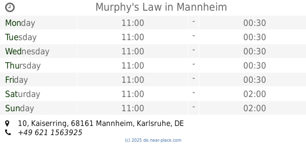
Murphys Law GmbH
Kaiserring 10, Mannheim
Bar
read more
1.017 km
Murphy's Law
Kaiserring 10, Mannheim
Bar
read more
1.024 km
Admiral Sportwetten GmbH
Kaiserring 36, Mannheim
Bar
read more
1.079 km
Mannheimer Waldhof Treff
L14 13, Mannheim
Bar
read more
1.107 km
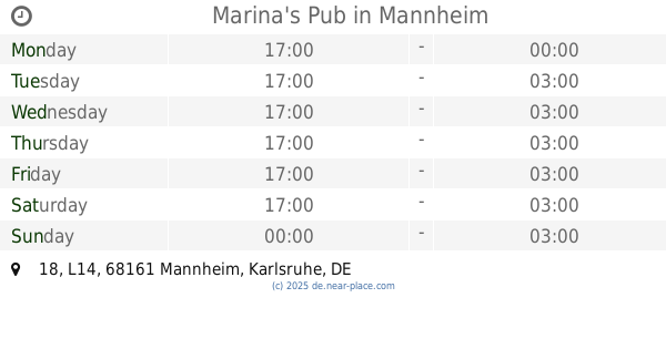
Marina's Pub
L14 18, Mannheim
Bar
read more
1.126 km
Cafe Legendär
N7 9, Mannheim
Bar
read more
1.127 km
Störtebeker Bar
L14 20, Mannheim
Bar
read more
1.127 km
Vapiano
Friedrichsplatz 1, Mannheim
Bar
read more
1.133 km
Ezgi Türkü Evi
N7 8, Mannheim
Bar
read more
1.681 km
De Stil.
N2 4, Mannheim
Bar
read more
1.727 km
Hartz 4 Kneipe
5,, P2 4, Mannheim
Bar
read more
1.815 km
Solo Mannheim
16, U4 15, Mannheim
Bar
read more
1.86 km
Dejavu Shisha Lounge
S1 10, Mannheim
Bar
read more
2.4 km
Santas Klause
G7 17, Mannheim
Bar
read more
2.519 km
Pate der Quadrate
Luisenring 16, Mannheim
Bar
read more
📑
all categories
Accounting
Administrative area level 1
Administrative area level 2
Airport
Amusement park
Aquarium
Art gallery
Atm
Bakery
Bank
Bar
Beauty salon
Bicycle store
Book store
Bowling alley
Bus station
Cafe
Campground
Car dealer
Car rental
Car repair
Car wash
Casino
Cemetery
Church
City hall
Clothing store
Colloquial area
Convenience store
Country
Courthouse
Dentist
Department store
Doctor
Electrician
Electronics store
Embassy
Establishment
Finance
Fire station
Florist
Food
Funeral home
Furniture store
Gas station
General contractor
Grocery or supermarket
Gym
Hair care
Hardware store
Health
Hindu Temple
Home goods store
Hospital
Insurance agency
Jewelry store
Laundry
Lawyer
Library
Light rail station
Liquor store
Local government office
Locality
Locksmith
Lodging
Meal delivery
Meal takeaway
Mosque
Movie rental
Movie theater
Moving company
Museum
Natural feature
Neighborhood
Night club
Painter
Park
Parking
Pet store
Pharmacy
Physiotherapist
Place of worship
Plumber
Point of interest
Police
Political
Post office
Premise
Real estate agency
Restaurant
Roofing contractor
Route
Rv park, camping
School
Shoe store
Shopping mall
Spa
Stadium
Storage
Store
Subpremise
Subway station
Supermarket
Synagogue
Taxi stand
Train station
Transit station
Travel agency
University
Veterinary care
Zoo
administrative area level 3
administrative area level 4
sublocality level 1
sublocality level 2
sublocality level 3
↑