Bar nearby ATLANTIC Hotel Kiel
Coronavirus disease (COVID-19) Situation
confirmed cases
38828995
deaths
183027
Germany
Bar nearby ATLANTIC Hotel Kiel
ATLANTIC Hotel Kiel
2, Raiffeisenstraße, 24103, Kiel, DE Deutschland
contacts phone
:
+49 431 374990
website:
www.atlantic-hotels.de
Latitude:
54.315932
, Longitude:
10.133182
larger map & directions
read more
nearest Bar
21 m
Deck 8 - die Bar im ATLANTIC Hotel Kiel
Raiffeisenstraße 2, Kiel
Bar
read more
141 m
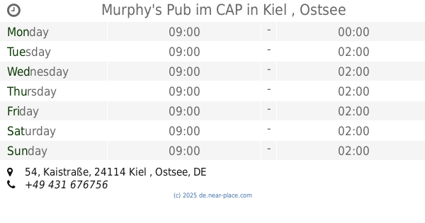
Murphy's Pub im CAP
Kaistraße 54, Kiel , Ostsee
Bar
read more
401 m
Sülo's Tanke
Walkerdamm 2, Kiel
Bar
read more
558 m
Hot Rock
Harriesstraße 1, Kiel
Bar
read more
599 m
Bierbar Barkadi
Exerzierplatz 7, Kiel
Bar
read more
645 m
Chaplin's Cocktail Bar
Waisenhofstraße 5A, Kiel
Bar
read more
649 m
Galerie Club 68
Ringstraße 68, Kiel
Bar
read more
672 m
Alhambra-Bar
Herzog-Friedrich-Straße 92, Kiel , Ostsee
Bar
read more
717 m
Jess Bar
Harmsstraße 65, Kiel
Bar
read more
762 m
Birdcage Kiel
Rathausstraße 10, Kiel
Bar
read more
776 m
Gaststätte "Bei Mr.Bond"
Sophienblatt 67, Kiel
Bar
read more
831 m
JuMe
Harmsstraße 83, Kiel
Bar
read more
860 m
X-TIP Sportwetten Kiel
Schuhmacherstraße 26, Kiel
Bar
read more
877 m
KASKADE
Wall 48, Kiel
Bar
read more
880 m
BierBar Tränke
Wall 50, Kiel
Bar
read more
918 m
ann Weinbar & Sushi
Alter Markt 8, Kiel
Bar
read more
926 m
Brauerei
Alter Markt 20, Kiel
Bar
read more
933 m
Bierlokal Quickborn
Jeßstraße 25, Kiel
Bar
read more
952 m
Bar Cultura
Kirchhofallee 83, Kiel
Bar
read more
952 m
Käpt'n Flint
Wall 58, Kiel
Bar
read more
998 m
Cafe Kreuzberg
Reeperbahn 17, Kiel , Ostsee
Bar
read more
1.053 km
Enja Wanneberger
Dänische Straße 30, Kiel
Bar
read more
1.118 km
Kaiser Bar
Kaiserstraße 63, Kiel
Bar
read more
1.166 km
Sternstunde
Jungfernstieg 27a, Kiel
Bar
read more
1.193 km
duray saglam
Iltisstraße 22, Kiel
Bar
read more
📑
all categories
Accounting
Administrative area level 1
Administrative area level 2
Airport
Amusement park
Aquarium
Art gallery
Atm
Bakery
Bank
Bar
Beauty salon
Bicycle store
Book store
Bowling alley
Bus station
Cafe
Campground
Car dealer
Car rental
Car repair
Car wash
Casino
Cemetery
Church
City hall
Clothing store
Colloquial area
Convenience store
Country
Courthouse
Dentist
Department store
Doctor
Electrician
Electronics store
Embassy
Establishment
Finance
Fire station
Florist
Food
Funeral home
Furniture store
Gas station
General contractor
Grocery or supermarket
Gym
Hair care
Hardware store
Health
Hindu Temple
Home goods store
Hospital
Insurance agency
Jewelry store
Laundry
Lawyer
Library
Light rail station
Liquor store
Local government office
Locality
Locksmith
Lodging
Meal delivery
Meal takeaway
Mosque
Movie rental
Movie theater
Moving company
Museum
Natural feature
Neighborhood
Night club
Painter
Park
Parking
Pet store
Pharmacy
Physiotherapist
Place of worship
Plumber
Point of interest
Police
Political
Post office
Premise
Real estate agency
Restaurant
Roofing contractor
Route
Rv park, camping
School
Shoe store
Shopping mall
Spa
Stadium
Storage
Store
Subpremise
Subway station
Supermarket
Synagogue
Taxi stand
Train station
Transit station
Travel agency
University
Veterinary care
Zoo
administrative area level 3
administrative area level 4
sublocality level 1
sublocality level 2
sublocality level 3
↑